Eruh night lights from space
Night Light of Eruh (Siirt) from space (Turkey) Src. Average luminocity for 10x10km area is 4.449% and for 50x50km: 2.7655%.
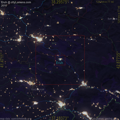
Analysis of Eruh night lights 2016
Square area 10x10 km:
100  0.17%
0.17%
90-99 0.51%
80-89 1.19%
70-79 0.17%
60-69 1.02%
50-59 0.17%
40-49 1.53%
30-39 0.68%
20-29 0.85%
10-19 0.17%
0-9 93.54%
0.17%90-99
0.51%80-89
1.19%70-79
0.17%60-69
1.02%50-59
0.17%40-49
1.53%30-39
0.68%20-29
0.85%10-19
0.17%0-9
93.54%Square area 50x50 km:
100 0.16%
90-99 0.63%
80-89 0.52%
70-79 0.12%
60-69 0.18%
50-59 0.29%
40-49 0.62%
30-39 0.61%
20-29 0.71%
10-19 1.62%
0-9 94.55%
0.16%90-99
0.63%80-89
0.52%70-79
0.12%60-69
0.18%50-59
0.29%40-49
0.62%30-39
0.61%20-29
0.71%10-19
1.62%0-9
94.55%Clear (daylight) street map image can be seen on geolist.org.
Map coordinates:
38° 17' 44.7" North, 41° 28' 16" East
37° 44' 30.6" North, 42° 10' 27.2" East
37° 11' 1.4" North, 42° 52' 38.5" East
Some cities around Eruh sort by population:
• Siirt
29.2 km =18.1 mi,  315°
315°
• Cizre
45.8 km =28.5 mi,  178°
178°
• Şırnak
35.4 km =22 mi,  135°
135°
• Kurtalan
47.6 km =29.6 mi,  295°
295°
• Dargeçit
45.8 km =28.5 mi,  241°
241°
• Pervari
39.4 km =24.5 mi,  56°
56°
• Şirvan
38 km =23.6 mi,  339°
339°
• Kumçatı
32.3 km =20.1 mi,  161°
161°
315378 (p: 7,868)
Sources (retrieved 2019-11-25):
» Earth at Night: Flat Maps 2012, 2016