Boyalık night lights from space
Night Light of Boyalık (Istanbul) from space (Turkey) Src. Average luminocity for 10x10km area is 6.0081% and for 50x50km: 21.3807%.
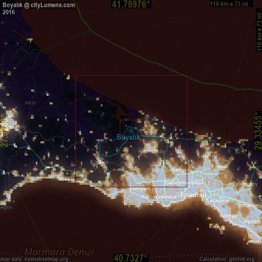
Analysis of Boyalık night lights 2016
Square area 10x10 km:
 0%
0%90-99
0%80-89
0%70-79
0.49%60-69
0.16%50-59
1.3%40-49
0.97%30-39
2.27%20-29
1.95%10-19
11.85%0-9
81.01%Square area 50x50 km:
4.44%90-99
3.58%80-89
1.95%70-79
2.62%60-69
3.41%50-59
4.01%40-49
2.18%30-39
3.18%20-29
6.94%10-19
8.65%0-9
59.04%Clear (daylight) street map image can be seen on geolist.org.
Map coordinates:
41° 47' 23.1" North, 27° 55' 41.9" East
41° 15' 48.1" North, 28° 37' 53.1" East
40° 43' 57.7" North, 29° 20' 4.4" East
Some cities around Boyalık sort by population:
• Sultangazi
26.4 km =16.4 mi,  131°
131°
• Esenyurt
26.6 km =16.5 mi,  171°
171°
• Arnavutköy
12.7 km =7.9 mi, 134°
• Başakşehir
23.7 km =14.7 mi,  142°
142°
• Büyükçekmece
27.3 km =17 mi,  188°
188°
• Mimarsinan
27.9 km =17.3 mi, 192°
• Tepecik
26.9 km =16.7 mi, 194°
• Çatalca
19.5 km =12.1 mi,  226°
226°
750446 (p: 11,835)
Sources (retrieved 2019-11-25):
» Earth at Night: Flat Maps 2012, 2016