Zaouiat Djedidi night lights from space
Night Light of Zaouiat Djedidi (Nābul) from space (Tunisia) Src. Average luminocity for 10x10km area is 23.9084% and for 50x50km: 13.1234%.
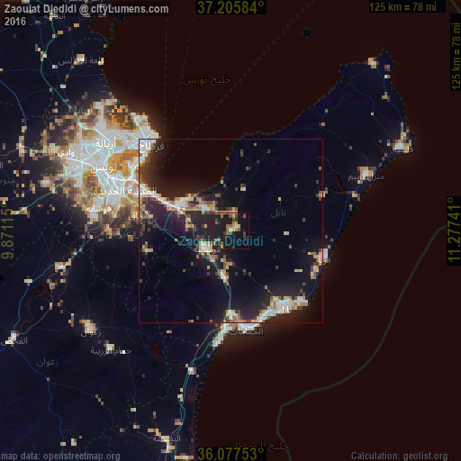
Analysis of Zaouiat Djedidi night lights 2016
Square area 10x10 km:
 0.92%
0.92%90-99
0.92%80-89
2.38%70-79
3.48%60-69
4.76%50-59
6.59%40-49
3.3%30-39
3.3%20-29
2.75%10-19
41.58%0-9
30.04%Square area 50x50 km:
1.62%90-99
1.51%80-89
1.83%70-79
1.46%60-69
1.85%50-59
1.14%40-49
1.88%30-39
2.37%20-29
4.28%10-19
13.6%0-9
68.47%Clear (daylight) street map image can be seen on geolist.org.
Map coordinates:
37° 12' 21" North, 9° 52' 16.1" East
36° 38' 37.5" North, 10° 34' 27.4" East
36° 4' 39.1" North, 11° 16' 38.7" East
Some cities around Zaouiat Djedidi sort by population:
• Nabeul
25.5 km =15.8 mi,  145°
145°
• Hammam-Lif
22.8 km =14.2 mi,  294°
294°
• Dar Chabanne
25.2 km =15.7 mi,  140°
140°
• La Sebala du Mornag
25.5 km =15.8 mi,  278°
278°
• Takelsa
16.4 km =10.2 mi,  18°
18°
• Mennzel Bou Zelfa
4.5 km =2.8 mi,  11°
11°
• Beni Khalled
1.6 km =1 mi,  62°
62°
• Bou Arkoub
11.9 km =7.4 mi,  190°
190°
2463951 (p: 6,583)
Sources (retrieved 2019-11-25):
» Earth at Night: Flat Maps 2012, 2016