Tagta night lights from space
Night Light of Tagta (Daşoguz) from space (Turkmenistan) Src. Average luminocity for 10x10km area is 27.0698% and for 50x50km: 10.5219%.
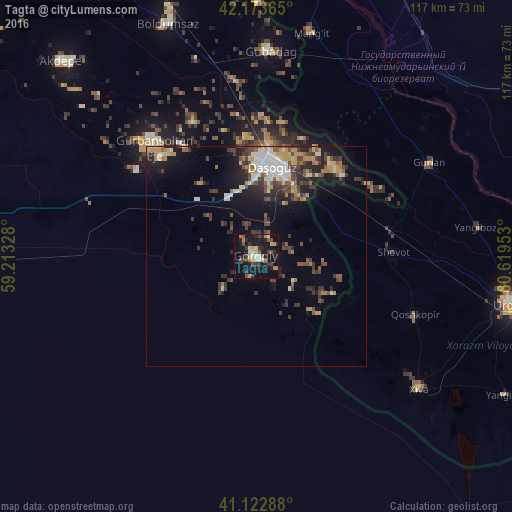
Analysis of Tagta night lights 2016
Square area 10x10 km:
 1.95%
1.95%90-99
3.41%80-89
4.06%70-79
2.6%60-69
3.25%50-59
2.92%40-49
5.19%30-39
6.98%20-29
6.33%10-19
36.36%0-9
26.95%Square area 50x50 km:
1.18%90-99
1.6%80-89
0.84%70-79
1.53%60-69
1.22%50-59
1.17%40-49
2.3%30-39
2.53%20-29
2.64%10-19
6.42%0-9
78.58%Clear (daylight) street map image can be seen on geolist.org.
Map coordinates:
42° 10' 25.1" North, 59° 12' 47.8" East
41° 39' 1.5" North, 59° 54' 59" East
41° 7' 22.4" North, 60° 37' 10.3" East
Some cities around Tagta sort by population:
• Daşoguz
21.1 km =13.1 mi,  11°
11°
• Khiwa, UZ
48 km =29.8 mi,  129°
129°
• Manghit, UZ
53.1 km =33 mi, 12°
• Gurlan, UZ
45 km =28 mi,  61°
61°
• Showot, UZ
32.1 km =19.9 mi,  88°
88°
• Yylanly
30 km =18.6 mi,  312°
312°
• Boldumsaz
56.9 km =35.4 mi,  339°
339°
• Qŭshkŭpir, UZ
37.9 km =23.5 mi,  109°
109°
601475 (p: 16,635)
Sources (retrieved 2019-11-25):
» Earth at Night: Flat Maps 2012, 2016