That Phanom night lights from space
Night Light of That Phanom (Nakhon Phanom) from space (Thailand) Src. Average luminocity for 10x10km area is 26.1623% and for 50x50km: 3.8724%.
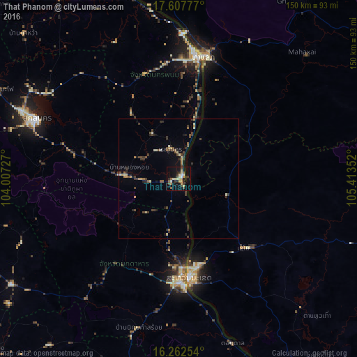
Analysis of That Phanom night lights 2016
Square area 10x10 km:
 0.65%
0.65%90-99
5.41%80-89
4.55%70-79
3.68%60-69
2.81%50-59
3.25%40-49
3.68%30-39
5.41%20-29
3.03%10-19
27.49%0-9
40.04%Square area 50x50 km:
0.03%90-99
0.56%80-89
0.49%70-79
0.45%60-69
0.33%50-59
0.5%40-49
1.06%30-39
1.07%20-29
0.74%10-19
1.65%0-9
93.12%Clear (daylight) street map image can be seen on geolist.org.
Map coordinates:
17° 36' 28" North, 104° 0' 26.2" East
16° 56' 10.9" North, 104° 42' 37.4" East
16° 15' 45.1" North, 105° 24' 48.7" East
Some cities around That Phanom sort by population:
• Thakhèk, LA
54.2 km =33.7 mi,  13°
13°
• Sakon Nakhon
64.9 km =40.3 mi,  292°
292°
• Savannakhet, LA
41.1 km =25.5 mi,  172°
172°
• Mukdahan
43.5 km =27 mi,  178°
178°
• Nakhon Phanom
53.2 km =33.1 mi, 7°
• Kuchinarai
82.9 km =51.5 mi,  237°
237°
• Khao Wong
71 km =44.1 mi,  248°
248°
• Moeiwadi
84.7 km =52.6 mi,  224°
224°
1605483 (p: 14,424)
Sources (retrieved 2019-11-25):
» Earth at Night: Flat Maps 2012, 2016