Huai Khot night lights from space
Night Light of Huai Khot (Uthai Thani) from space (Thailand) Src. Average luminocity for 10x10km area is 1.6178% and for 50x50km: 2.2568%.
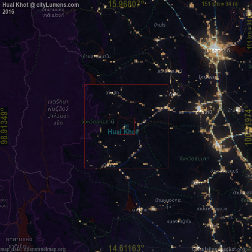
Analysis of Huai Khot night lights 2016
Square area 10x10 km:
 0%
0%90-99
0%80-89
0.83%70-79
0%60-69
0%50-59
0%40-49
0.83%30-39
0.83%20-29
0%10-19
0%0-9
97.52%Square area 50x50 km:
0%90-99
0.02%80-89
0.3%70-79
0.27%60-69
0.66%50-59
0.36%40-49
0.55%30-39
0.92%20-29
0.63%10-19
0.22%0-9
96.06%Clear (daylight) street map image can be seen on geolist.org.
Map coordinates:
15° 58' 5.1" North, 98° 54' 48.6" East
15° 17' 27.4" North, 99° 36' 59.8" East
14° 36' 41.9" North, 100° 19' 11.1" East
Some cities around Huai Khot sort by population:
• Nakhon Sawan
72.3 km =44.9 mi,  50°
50°
• Uthai Thani
44.8 km =27.8 mi,  77°
77°
• Lat Yao
54.4 km =33.8 mi,  19°
19°
• Thap Than
35 km =21.7 mi,  57°
57°
• Chai Nat
55.6 km =34.5 mi,  102°
102°
• Doembang Nangbuat
72.7 km =45.2 mi,  134°
134°
• Lan Sak
18.5 km =11.5 mi,  346°
346°
• Phayuha Khiri
58.5 km =36.4 mi,  71°
71°
1153263 (p: 5,940)
Sources (retrieved 2019-11-25):
» Earth at Night: Flat Maps 2012, 2016