Al Quţayfah night lights from space
Night Light of Al Quţayfah (Rif-dimashq) from space (Syria) Src. Average luminocity for 10x10km area is 12.5% and for 50x50km: 5.7621%.
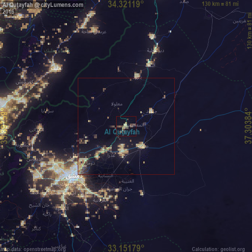
Analysis of Al Quţayfah night lights 2016
Square area 10x10 km:
 0%
0%90-99
0%80-89
2.01%70-79
0.92%60-69
1.47%50-59
1.47%40-49
5.68%30-39
6.59%20-29
1.65%10-19
0.73%0-9
79.49%Square area 50x50 km:
0.01%90-99
0.07%80-89
1.81%70-79
0.87%60-69
0.57%50-59
0.66%40-49
1.19%30-39
1.19%20-29
1.25%10-19
4.49%0-9
87.89%Clear (daylight) street map image can be seen on geolist.org.
Map coordinates:
34° 19' 16.3" North, 35° 53' 51.3" East
33° 44' 18.5" North, 36° 36' 2.6" East
33° 9' 6.4" North, 37° 18' 13.8" East
Some cities around Al Quţayfah sort by population:
• Douma
26.1 km =16.2 mi,  224°
224°
• At Tall
30.4 km =18.9 mi,  242°
242°
• An Nabk
33.9 km =21.1 mi,  20°
20°
• ‘Irbīn
31.2 km =19.4 mi, 224°
• Yabrūd
26.2 km =16.3 mi,  11°
11°
• Ḩarastā
29.6 km =18.4 mi,  227°
227°
• Jayrūd
14.9 km =9.3 mi,  59°
59°
• Dayr al ‘Aşāfīr
34.6 km =21.5 mi,  208°
208°
173312 (p: 16,118)
Sources (retrieved 2019-11-25):
» Earth at Night: Flat Maps 2012, 2016