San Antonio del Monte night lights from space
Night Light of San Antonio del Monte (Sonsonate) from space (El Salvador) Src. Average luminocity for 10x10km area is 23.8017% and for 50x50km: 3.5116%.
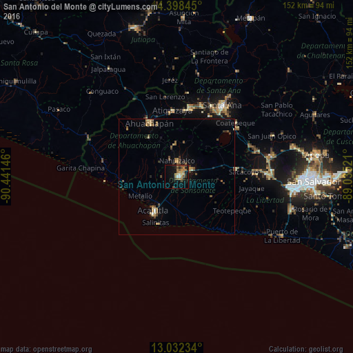
Analysis of San Antonio del Monte night lights 2016
Square area 10x10 km:
 1.03%
1.03%90-99
1.65%80-89
4.13%70-79
1.45%60-69
9.92%50-59
1.86%40-49
6.2%30-39
2.27%20-29
5.58%10-19
16.32%0-9
49.59%Square area 50x50 km:
0.07%90-99
0.21%80-89
0.49%70-79
0.44%60-69
0.81%50-59
0.56%40-49
0.86%30-39
0.45%20-29
0.6%10-19
1.76%0-9
93.74%Clear (daylight) street map image can be seen on geolist.org.
Map coordinates:
14° 23' 54.4" North, 90° 26' 29.3" West
13° 42' 59" North, 89° 44' 18" West
13° 1' 56.4" North, 89° 2' 6.8" West
Some cities around San Antonio del Monte sort by population:
• Sonsonate
1.6 km =1 mi,  79°
79°
• Ahuachapán
25.5 km =15.8 mi,  333°
333°
• Acajutla
16.8 km =10.4 mi,  215°
215°
• Izalco
7.7 km =4.8 mi,  65°
65°
• Sonzacate
3.2 km =2 mi,  52°
52°
• Juayúa
13.9 km =8.6 mi,  356°
356°
• Concepción de Ataco
20.8 km =12.9 mi, 325°
• Nahuizalco
6.8 km =4.2 mi,  1°
1°
3583851 (p: 9,135)
Sources (retrieved 2019-11-25):
» Earth at Night: Flat Maps 2012, 2016