Serravalle night lights from space
Night Light of Serravalle from space (San Marino) Src. Average luminocity for 10x10km area is 46.4762% and for 50x50km: 23.0036%.
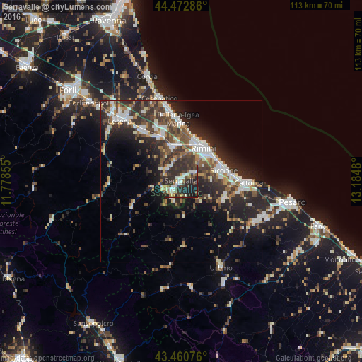
Analysis of Serravalle night lights 2016
Square area 10x10 km:
 8.41%
8.41%90-99
9.37%80-89
3.65%70-79
1.27%60-69
5.56%50-59
5.56%40-49
9.05%30-39
12.38%20-29
33.81%10-19
10.95%0-9
0%Square area 50x50 km:
3.69%90-99
4.69%80-89
1.61%70-79
1.84%60-69
2.44%50-59
3.57%40-49
4.36%30-39
4.74%20-29
9.94%10-19
10.79%0-9
52.34%Clear (daylight) street map image can be seen on geolist.org.
Map coordinates:
44° 28' 22.3" North, 11° 46' 42.8" East
43° 58' 8.3" North, 12° 28' 54" East
43° 27' 38.7" North, 13° 11' 5.3" East
Some cities around Serravalle sort by population:
• Villa Verucchio, IT
5.4 km =3.4 mi,  317°
317°
• Borgo Maggiore
4.1 km =2.5 mi,  222°
222°
• San Marino
4.6 km =2.9 mi, 218°
• Domagnano
2.4 km =1.5 mi,  206°
206°
• Fiorentino
6.8 km =4.2 mi,  196°
196°
• Acquaviva
5.7 km =3.5 mi,  243°
243°
• Faetano
4.7 km =2.9 mi,  163°
163°
• Monte Giardino
6.7 km =4.2 mi,  179°
179°
3166645 (p: 9,258)
Sources (retrieved 2019-11-25):
» Earth at Night: Flat Maps 2012, 2016