Domagnano night lights from space
Night Light of Domagnano from space (San Marino) Src. Average luminocity for 10x10km area is 45.8238% and for 50x50km: 22.2231%.
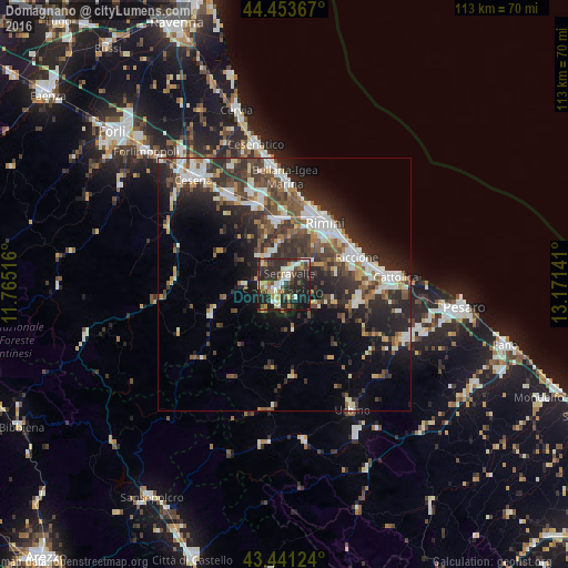
Analysis of Domagnano night lights 2016
Square area 10x10 km:
 6.83%
6.83%90-99
9.37%80-89
6.35%70-79
2.22%60-69
6.19%50-59
4.13%40-49
8.57%30-39
9.05%20-29
28.89%10-19
18.1%0-9
0.32%Square area 50x50 km:
3.55%90-99
4.63%80-89
1.62%70-79
1.7%60-69
2.31%50-59
3.37%40-49
4.17%30-39
4.54%20-29
9.27%10-19
10.57%0-9
54.27%Clear (daylight) street map image can be seen on geolist.org.
Map coordinates:
44° 27' 13.2" North, 11° 45' 54.6" East
43° 56' 58.6" North, 12° 28' 5.8" East
43° 26' 28.5" North, 13° 10' 17.1" East
Some cities around Domagnano sort by population:
• Serravalle
2.4 km =1.5 mi,  26°
26°
• Borgo Maggiore
1.9 km =1.2 mi,  242°
242°
• San Marino
2.3 km =1.4 mi,  230°
230°
• Fiorentino
4.5 km =2.8 mi,  191°
191°
• Acquaviva
4 km =2.5 mi,  264°
264°
• Faetano
3.4 km =2.1 mi,  134°
134°
• Poggio di Chiesanuova
6.3 km =3.9 mi,  216°
216°
• Monte Giardino
4.7 km =2.9 mi,  166°
166°
3177542 (p: 3,161)
Sources (retrieved 2019-11-25):
» Earth at Night: Flat Maps 2012, 2016