Holíč night lights from space
Night Light of Holíč (Trnavský kraj) from space (Slovakia) Src. Average luminocity for 10x10km area is 12.8139% and for 50x50km: 4.5565%.
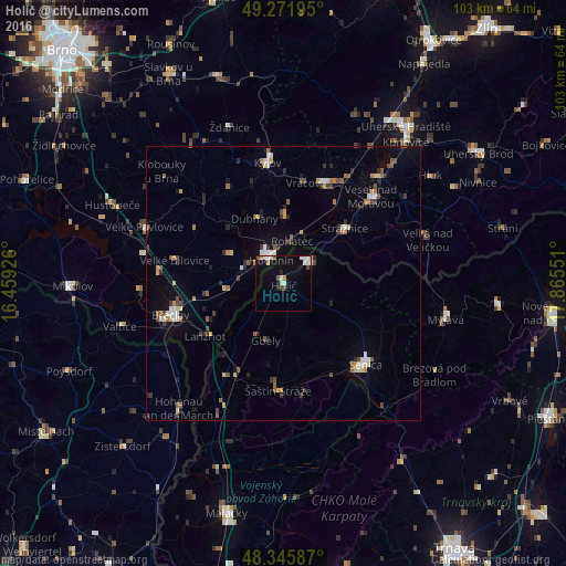
Analysis of Holíč night lights 2016
Square area 10x10 km:
 2.7%
2.7%90-99
2.98%80-89
1.14%70-79
0.57%60-69
0.71%50-59
1.56%40-49
0.85%30-39
0.85%20-29
0.57%10-19
5.97%0-9
82.1%Square area 50x50 km:
0.45%90-99
0.65%80-89
0.43%70-79
0.44%60-69
0.49%50-59
0.72%40-49
0.65%30-39
0.6%20-29
0.81%10-19
1.51%0-9
93.25%Clear (daylight) street map image can be seen on geolist.org.
Map coordinates:
49° 16' 19" North, 16° 27' 33.3" East
48° 48' 39.8" North, 17° 9' 44.6" East
48° 20' 45.1" North, 17° 51' 55.8" East
Some cities around Holíč sort by population:
• Hodonín, CZ
4.7 km =2.9 mi,  332°
332°
• Břeclav, CZ
21.3 km =13.2 mi,  254°
254°
• Senica
21 km =13 mi,  134°
134°
• Skalica
6 km =3.7 mi,  51°
51°
• Veselí nad Moravou, CZ
22.3 km =13.9 mi,  44°
44°
• Dubňany, CZ
12.9 km =8 mi,  335°
335°
• Strážnice, CZ
15.1 km =9.4 mi, 48°
• Gbely
10.9 km =6.8 mi,  198°
198°
3060077 (p: 11,416)
Sources (retrieved 2019-11-25):
» Earth at Night: Flat Maps 2012, 2016