Dubňany night lights from space
Night Light of Dubňany (South Moravian) from space (Czech Republic) Src. Average luminocity for 10x10km area is 4.1818% and for 50x50km: 4.5606%.
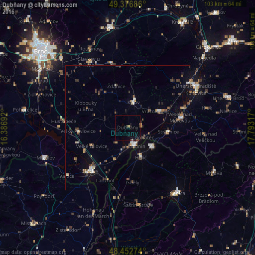
Analysis of Dubňany night lights 2016
Square area 10x10 km:
 0%
0%90-99
0.28%80-89
0.28%70-79
0.28%60-69
0%50-59
0.28%40-49
0.85%30-39
0.85%20-29
1.42%10-19
2.7%0-9
93.04%Square area 50x50 km:
0.41%90-99
0.68%80-89
0.32%70-79
0.42%60-69
0.49%50-59
0.64%40-49
0.7%30-39
0.8%20-29
0.98%10-19
1.64%0-9
92.93%Clear (daylight) street map image can be seen on geolist.org.
Map coordinates:
49° 22' 36.7" North, 16° 23' 12.9" East
48° 55' 1" North, 17° 5' 24.1" East
48° 27' 9.9" North, 17° 47' 35.4" East
Some cities around Dubňany sort by population:
• Hodonín
8.2 km =5.1 mi,  157°
157°
• Břeclav
23.2 km =14.4 mi,  220°
220°
• Skalica, SK
12.8 km =8 mi,  128°
128°
• Kyjov
10.6 km =6.6 mi,  12°
12°
• Veselí nad Moravou
21.3 km =13.2 mi,  78°
78°
• Holíč, SK
12.9 km =8 mi, 155°
• Strážnice
16.7 km =10.4 mi,  96°
96°
• Gbely, SK
22.2 km =13.8 mi,  175°
175°
3076329 (p: 6,649)
Sources (retrieved 2019-11-25):
» Earth at Night: Flat Maps 2012, 2016