Razkrižje night lights from space
Night Light of Razkrižje from space (Slovenia) Src. Average luminocity for 10x10km area is 0.804% and for 50x50km: 4.4519%.
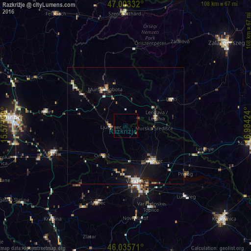
Analysis of Razkrižje night lights 2016
Square area 10x10 km:
 0%
0%90-99
0%80-89
0%70-79
0%60-69
0%50-59
0.57%40-49
0.28%30-39
0%20-29
0.43%10-19
0.43%0-9
98.3%Square area 50x50 km:
0.52%90-99
0.73%80-89
0.38%70-79
0.34%60-69
0.42%50-59
0.88%40-49
0.63%30-39
0.71%20-29
0.83%10-19
2.92%0-9
91.64%Clear (daylight) street map image can be seen on geolist.org.
Map coordinates:
47° 0' 12" North, 15° 34' 40.8" East
46° 31' 18" North, 16° 16' 52" East
46° 2' 8.6" North, 16° 59' 3.3" East
Some cities around Razkrižje sort by population:
• Ljutomer
6.4 km =4 mi,  269°
269°
• Beltinci
9.8 km =6.1 mi,  341°
341°
• Odranci
7.2 km =4.5 mi,  359°
359°
• Turnišče
12.2 km =7.6 mi,  14°
14°
• Črenšovci
4.4 km =2.7 mi,  23°
23°
• Velika Polana
7.5 km =4.7 mi,  42°
42°
• Veržej
11.2 km =7 mi,  307°
307°
• Križevci pri Ljutomeru
12.1 km =7.5 mi,  295°
295°
3215453 (p: 252)
Sources (retrieved 2019-11-25):
» Earth at Night: Flat Maps 2012, 2016