Postojna night lights from space
Night Light of Postojna from space (Slovenia) Src. Average luminocity for 10x10km area is 5.8413% and for 50x50km: 1.524%.
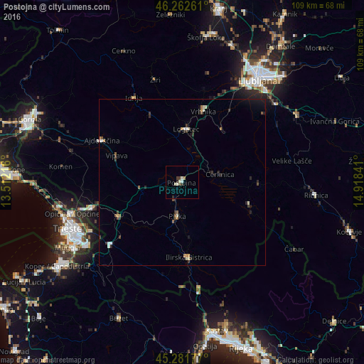
Analysis of Postojna night lights 2016
Square area 10x10 km:
100  0%
0%
90-99 2.7%
80-89 0.48%
70-79 0%
60-69 0.63%
50-59 0.63%
40-49 0.48%
30-39 2.06%
20-29 0.63%
10-19 0%
0-9 92.38%
0%90-99
2.7%80-89
0.48%70-79
0%60-69
0.63%50-59
0.63%40-49
0.48%30-39
2.06%20-29
0.63%10-19
0%0-9
92.38%Square area 50x50 km:
100 0.08%
90-99 0.32%
80-89 0.12%
70-79 0.15%
60-69 0.19%
50-59 0.24%
40-49 0.18%
30-39 0.38%
20-29 0.41%
10-19 0.49%
0-9 97.45%
0.08%90-99
0.32%80-89
0.12%70-79
0.15%60-69
0.19%50-59
0.24%40-49
0.18%30-39
0.38%20-29
0.41%10-19
0.49%0-9
97.45%Clear (daylight) street map image can be seen on geolist.org.
Map coordinates:
46° 15' 45.4" North, 13° 30' 43.8" East
45° 46' 27.7" North, 14° 12' 55" East
45° 16' 54.4" North, 14° 55' 6.3" East
Some cities around Postojna sort by population:
• Logatec
15.6 km =9.7 mi,  3°
3°
• Vrhnika
21.9 km =13.6 mi,  16°
16°
• Cerknica
11.6 km =7.2 mi,  79°
79°
• Borovnica
19.5 km =12.1 mi,  36°
36°
• Pivka
10.3 km =6.4 mi,  188°
188°
• Vipava
21.1 km =13.1 mi,  292°
292°
• Divača
21.5 km =13.4 mi,  242°
242°
• Nova Vas
22.5 km =14 mi,  90°
90°
3192673 (p: 9,183)
Sources (retrieved 2019-11-25):
» Earth at Night: Flat Maps 2012, 2016