Vipava night lights from space
Night Light of Vipava from space (Slovenia) Src. Average luminocity for 10x10km area is 2.744% and for 50x50km: 5.0253%.
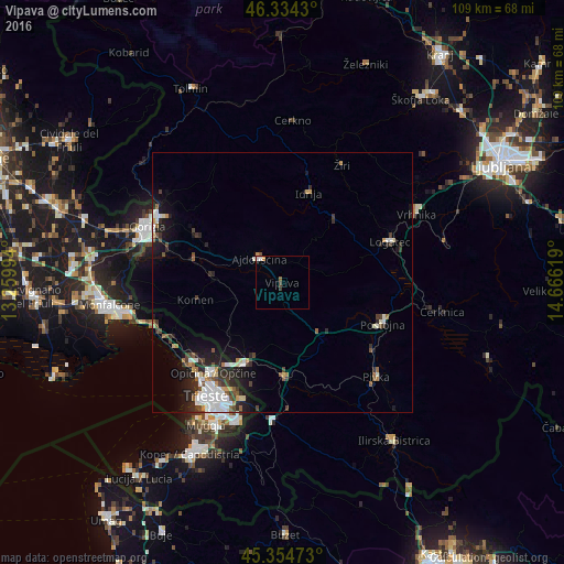
Analysis of Vipava night lights 2016
Square area 10x10 km:
100  0.6%
0.6%
90-99 0.6%
80-89 0%
70-79 0.6%
60-69 0%
50-59 0.6%
40-49 0.6%
30-39 0.6%
20-29 0%
10-19 0%
0-9 96.43%
0.6%90-99
0.6%80-89
0%70-79
0.6%60-69
0%50-59
0.6%40-49
0.6%30-39
0.6%20-29
0%10-19
0%0-9
96.43%Square area 50x50 km:
100 0.91%
90-99 1.05%
80-89 0.37%
70-79 0.39%
60-69 0.4%
50-59 0.66%
40-49 0.66%
30-39 0.83%
20-29 1.55%
10-19 2.96%
0-9 90.22%
0.91%90-99
1.05%80-89
0.37%70-79
0.39%60-69
0.4%50-59
0.66%40-49
0.66%30-39
0.83%20-29
1.55%10-19
2.96%0-9
90.22%Clear (daylight) street map image can be seen on geolist.org.
Map coordinates:
46° 20' 3.5" North, 13° 15' 35.8" East
45° 50' 48" North, 13° 57' 47" East
45° 21' 17" North, 14° 39' 58.3" East
Some cities around Vipava sort by population:
• Postojna
21.1 km =13.1 mi,  112°
112°
• Logatec
21.7 km =13.5 mi,  69°
69°
• Villa Opicina, IT
22.3 km =13.9 mi,  217°
217°
• Ajdovščina
6 km =3.7 mi,  316°
316°
• Idrija
18.1 km =11.2 mi,  16°
16°
• Sežana
16.8 km =10.4 mi,  204°
204°
• Divača
18 km =11.2 mi,  178°
178°
• Komen
17 km =10.6 mi,  258°
258°
3187706 (p: 1,771)
Sources (retrieved 2019-11-25):
» Earth at Night: Flat Maps 2012, 2016