Cerknica night lights from space
Night Light of Cerknica from space (Slovenia) Src. Average luminocity for 10x10km area is 0.8467% and for 50x50km: 1.6102%.
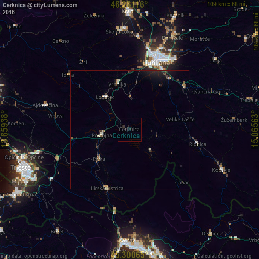
Analysis of Cerknica night lights 2016
Square area 10x10 km:
 0%
0%90-99
0%80-89
0%70-79
0%60-69
0%50-59
0%40-49
0%30-39
0.6%20-29
2.08%10-19
0.3%0-9
97.02%Square area 50x50 km:
0.04%90-99
0.25%80-89
0.1%70-79
0.13%60-69
0.2%50-59
0.21%40-49
0.24%30-39
0.37%20-29
0.8%10-19
1.31%0-9
96.35%Clear (daylight) street map image can be seen on geolist.org.
Map coordinates:
46° 16' 52.2" North, 13° 39' 33.8" East
45° 47' 35" North, 14° 21' 45" East
45° 18' 2.3" North, 15° 3' 56.3" East
Some cities around Cerknica sort by population:
• Postojna
11.6 km =7.2 mi,  259°
259°
• Logatec
17.2 km =10.7 mi,  321°
321°
• Vrhnika
19.7 km =12.2 mi,  344°
344°
• Borovnica
13.7 km =8.5 mi,  0°
0°
• Pivka
17.8 km =11.1 mi,  226°
226°
• Sodražica
21.5 km =13.4 mi,  99°
99°
• Leskova Dolina
20.6 km =12.8 mi,  158°
158°
• Nova Vas
11.4 km =7.1 mi, 102°
3202709 (p: 3,928)
Sources (retrieved 2019-11-25):
» Earth at Night: Flat Maps 2012, 2016