Ivančna Gorica night lights from space
Night Light of Ivančna Gorica from space (Slovenia) Src. Average luminocity for 10x10km area is 1.125% and for 50x50km: 5.3307%.
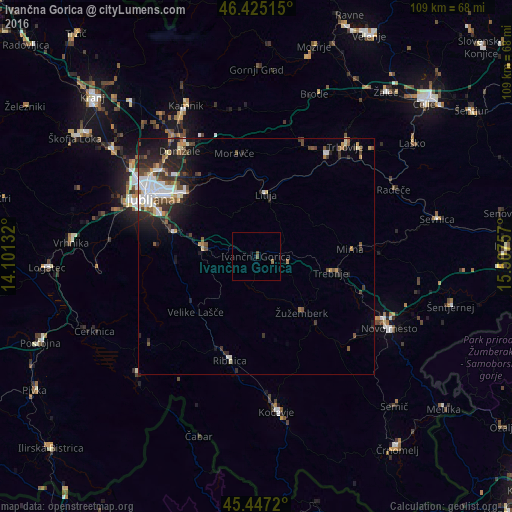
Analysis of Ivančna Gorica night lights 2016
Square area 10x10 km:
 0%
0%90-99
0%80-89
0%70-79
0%60-69
0.6%50-59
0.3%40-49
0.89%30-39
0%20-29
0%10-19
0.6%0-9
97.62%Square area 50x50 km:
0.97%90-99
0.99%80-89
0.47%70-79
0.35%60-69
0.54%50-59
0.75%40-49
0.98%30-39
0.8%20-29
1.92%10-19
3.05%0-9
89.18%Clear (daylight) street map image can be seen on geolist.org.
Map coordinates:
46° 25' 30.5" North, 14° 6' 4.8" East
45° 56' 18" North, 14° 48' 16" East
45° 26' 49.9" North, 15° 30' 27.3" East
Some cities around Ivančna Gorica sort by population:
• Grosuplje
11.4 km =7.1 mi,  279°
279°
• Litija
13.4 km =8.3 mi,  5°
5°
• Trebnje
17.2 km =10.7 mi,  102°
102°
• Škofljica
18.3 km =11.4 mi,  285°
285°
• Šmartno pri Litiji
12.2 km =7.6 mi, 14°
• Žužemberk
15.1 km =9.4 mi,  140°
140°
• Velike Lašče
17.6 km =10.9 mi,  227°
227°
• Videm
13 km =8.1 mi,  220°
220°
3199078 (p: 1,988)
Sources (retrieved 2019-11-25):
» Earth at Night: Flat Maps 2012, 2016