Litija night lights from space
Night Light of Litija from space (Slovenia) Src. Average luminocity for 10x10km area is 1.5327% and for 50x50km: 5.5948%.
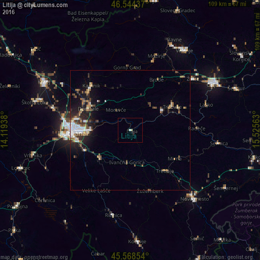
Analysis of Litija night lights 2016
Square area 10x10 km:
 0.43%
0.43%90-99
0.14%80-89
0.57%70-79
0%60-69
0%50-59
0%40-49
0%30-39
0%20-29
0.71%10-19
1.56%0-9
96.59%Square area 50x50 km:
0.78%90-99
0.89%80-89
0.47%70-79
0.53%60-69
0.64%50-59
0.92%40-49
1.13%30-39
0.8%20-29
1.72%10-19
3.67%0-9
88.46%Clear (daylight) street map image can be seen on geolist.org.
Map coordinates:
46° 32' 39.7" North, 14° 7' 9.8" East
46° 3' 31" North, 14° 49' 21" East
45° 34' 6.7" North, 15° 31' 32.3" East
Some cities around Litija sort by population:
• Domžale
19.7 km =12.2 mi,  296°
296°
• Grosuplje
17.1 km =10.6 mi,  227°
227°
• Zagorje ob Savi
15.7 km =9.8 mi,  58°
58°
• Ivančna Gorica
13.4 km =8.3 mi,  185°
185°
• Šmartno pri Litiji
2.3 km =1.4 mi,  133°
133°
• Moravče
10.6 km =6.6 mi,  325°
325°
• Lukovica pri Domžalah
16 km =9.9 mi,  320°
320°
• Dol pri Ljubljani
17.4 km =10.8 mi,  281°
281°
3196425 (p: 6,467)
Sources (retrieved 2019-11-25):
» Earth at Night: Flat Maps 2012, 2016