Västra Frölunda night lights from space
Night Light of Västra Frölunda (Västra Götaland) from space (Sweden) Src. Average luminocity for 10x10km area is 75.0429% and for 50x50km: 19.1691%.
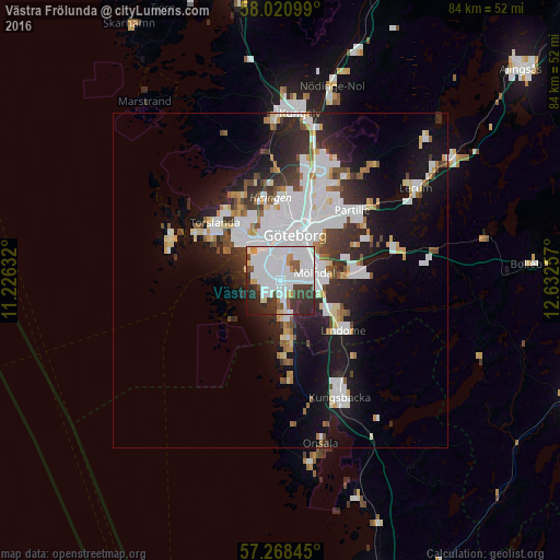
Analysis of Västra Frölunda night lights 2016
Square area 10x10 km:
 37.5%
37.5%90-99
20.95%80-89
2.5%70-79
3.69%60-69
1.19%50-59
4.52%40-49
4.17%30-39
12.02%20-29
10.24%10-19
3.1%0-9
0.12%Square area 50x50 km:
6.05%90-99
4.57%80-89
1.36%70-79
1.29%60-69
1.31%50-59
1.26%40-49
1.68%30-39
2.58%20-29
4.57%10-19
10.03%0-9
65.31%Clear (daylight) street map image can be seen on geolist.org.
Map coordinates:
58° 1' 15.6" North, 11° 13' 34.8" East
57° 38' 48" North, 11° 55' 46" East
57° 16' 6.4" North, 12° 37' 57.3" East
Some cities around Västra Frölunda sort by population:
• Göteborg
7.1 km =4.4 mi,  18°
18°
• Mölndal
5.1 km =3.2 mi,  79°
79°
• Majorna
5.1 km =3.2 mi,  351°
351°
• Mölnlycke
11.3 km =7 mi, 83°
• Billdal
8.9 km =5.5 mi,  178°
178°
• Lindome
12.8 km =8 mi,  134°
134°
• Torslanda
12.8 km =8 mi,  312°
312°
• Kållered
8.3 km =5.2 mi,  119°
119°
2664050 (p: 15,924)
Sources (retrieved 2019-11-25):
» Earth at Night: Flat Maps 2012, 2016