Tensta night lights from space
Night Light of Tensta (Stockholm) from space (Sweden) Src. Average luminocity for 10x10km area is 91.9881% and for 50x50km: 39.4077%.
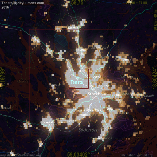
Analysis of Tensta night lights 2016
Square area 10x10 km:
100  47.84%
90-99 33.44%
80-89 3.03%
70-79 5.09%
60-69 1.08%
50-59 1.41%
40-49 6.49%
30-39 1.52%
20-29 0.11%
10-19 0%
0-9 0%
47.84%90-99
33.44%80-89
3.03%70-79
5.09%60-69
1.08%50-59
1.41%40-49
6.49%30-39
1.52%20-29
0.11%10-19
0%0-9
0%Square area 50x50 km:
100 12.1%
90-99 9.89%
80-89 3%
70-79 3.6%
60-69 3.47%
50-59 3.45%
40-49 3.57%
30-39 4.49%
20-29 8.39%
10-19 15.15%
0-9 32.9%
12.1%90-99
9.89%80-89
3%70-79
3.6%60-69
3.47%50-59
3.45%40-49
3.57%30-39
4.49%20-29
8.39%10-19
15.15%0-9
32.9%Clear (daylight) street map image can be seen on geolist.org.
Map coordinates:
59° 45' 0" North, 17° 11' 52.8" East
59° 23' 38" North, 17° 54' 4" East
59° 2' 2.5" North, 18° 36' 15.3" East
Some cities around Tensta sort by population:
• Sollentuna
4.7 km =2.9 mi,  36°
36°
• Solna
6.8 km =4.2 mi,  123°
123°
• Bromma
6.4 km =4 mi,  159°
159°
• Sundbyberg
5.4 km =3.4 mi,  132°
132°
• Jakobsberg
4.9 km =3 mi,  310°
310°
• Råsunda
6.2 km =3.9 mi, 120°
• Kista
2.7 km =1.7 mi,  67°
67°
• Akalla
2.4 km =1.5 mi,  17°
17°
7304427 (p: 17,083)
Sources (retrieved 2019-11-25):
» Earth at Night: Flat Maps 2012, 2016