Kista night lights from space
Night Light of Kista (Stockholm) from space (Sweden) Src. Average luminocity for 10x10km area is 89.3853% and for 50x50km: 39.5439%.
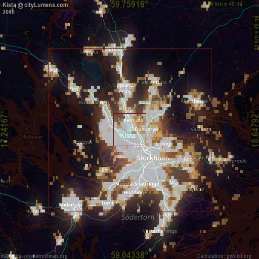
Analysis of Kista night lights 2016
Square area 10x10 km:
100  42.64%
90-99 29.33%
80-89 3.9%
70-79 11.26%
60-69 2.06%
50-59 1.52%
40-49 8.55%
30-39 0.76%
20-29 0%
10-19 0%
0-9 0%
42.64%90-99
29.33%80-89
3.9%70-79
11.26%60-69
2.06%50-59
1.52%40-49
8.55%30-39
0.76%20-29
0%10-19
0%0-9
0%Square area 50x50 km:
100 11.99%
90-99 9.91%
80-89 3%
70-79 3.65%
60-69 3.5%
50-59 3.53%
40-49 3.78%
30-39 4.41%
20-29 8.17%
10-19 16.02%
0-9 32.04%
11.99%90-99
9.91%80-89
3%70-79
3.65%60-69
3.5%50-59
3.53%40-49
3.78%30-39
4.41%20-29
8.17%10-19
16.02%0-9
32.04%Clear (daylight) street map image can be seen on geolist.org.
Map coordinates:
59° 45' 33" North, 17° 14' 30" East
59° 24' 11.4" North, 17° 56' 41.2" East
59° 2' 36.2" North, 18° 38' 52.5" East
Some cities around Kista sort by population:
• Sollentuna
2.8 km =1.7 mi,  7°
7°
• Solna
5.8 km =3.6 mi,  146°
146°
• Sundbyberg
4.9 km =3 mi,  162°
162°
• Tensta
2.7 km =1.7 mi,  247°
247°
• Råsunda
5 km =3.1 mi, 145°
• Djursholm
6.3 km =3.9 mi,  93°
93°
• Akalla
2.2 km =1.4 mi,  306°
306°
• Bergshamra
5.6 km =3.5 mi,  116°
116°
2700791 (p: 10,254)
Sources (retrieved 2019-11-25):
» Earth at Night: Flat Maps 2012, 2016