Skåre night lights from space
Night Light of Skåre (Värmland) from space (Sweden) Src. Average luminocity for 10x10km area is 22.9123% and for 50x50km: 5.4221%.
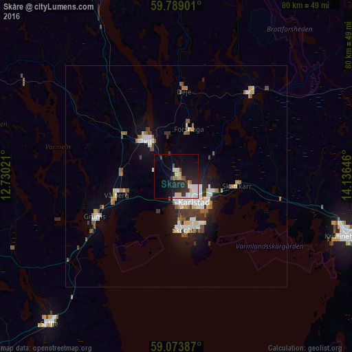
Analysis of Skåre night lights 2016
Square area 10x10 km:
 5.09%
5.09%90-99
4.22%80-89
3.25%70-79
1.41%60-69
0.87%50-59
1.41%40-49
1.73%30-39
2.49%20-29
9.74%10-19
17.64%0-9
52.16%Square area 50x50 km:
0.97%90-99
1.12%80-89
0.5%70-79
0.39%60-69
0.61%50-59
0.65%40-49
0.58%30-39
0.79%20-29
1.02%10-19
3.17%0-9
90.21%Clear (daylight) street map image can be seen on geolist.org.
Map coordinates:
59° 47' 20.4" North, 12° 43' 48.8" East
59° 25' 60" North, 13° 25' 60" East
59° 4' 25.9" North, 14° 8' 11.3" East
Some cities around Skåre sort by population:
• Karlstad
7.2 km =4.5 mi,  146°
146°
• Kristinehamn
40.6 km =25.2 mi,  109°
109°
• Skoghall
12.4 km =7.7 mi,  171°
171°
• Säffle
44.1 km =27.4 mi,  220°
220°
• Kil
10.3 km =6.4 mi,  318°
318°
• Forshaga
10.6 km =6.6 mi,  14°
14°
• Grums
20.4 km =12.7 mi,  243°
243°
• Sunne
47.8 km =29.7 mi,  340°
340°
2678156 (p: 5,444)
Sources (retrieved 2019-11-25):
» Earth at Night: Flat Maps 2012, 2016