Kil night lights from space
Night Light of Kil (Värmland) from space (Sweden) Src. Average luminocity for 10x10km area is 15.9739% and for 50x50km: 5.4151%.
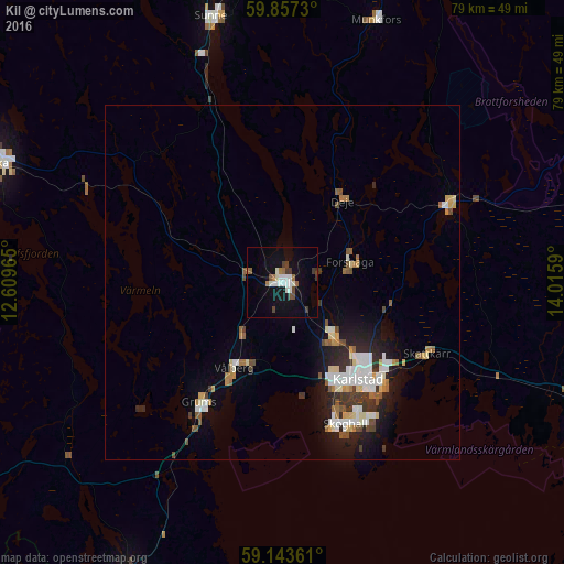
Analysis of Kil night lights 2016
Square area 10x10 km:
100  2.38%
2.38%
90-99 4.54%
80-89 0.34%
70-79 0%
60-69 2.27%
50-59 1.81%
40-49 1.93%
30-39 2.83%
20-29 0%
10-19 13.27%
0-9 70.63%
2.38%90-99
4.54%80-89
0.34%70-79
0%60-69
2.27%50-59
1.81%40-49
1.93%30-39
2.83%20-29
0%10-19
13.27%0-9
70.63%Square area 50x50 km:
100 0.98%
90-99 1.13%
80-89 0.5%
70-79 0.39%
60-69 0.6%
50-59 0.63%
40-49 0.55%
30-39 0.79%
20-29 1.08%
10-19 3.2%
0-9 90.13%
0.98%90-99
1.13%80-89
0.5%70-79
0.39%60-69
0.6%50-59
0.63%40-49
0.55%30-39
0.79%20-29
1.08%10-19
3.2%0-9
90.13%Clear (daylight) street map image can be seen on geolist.org.
Map coordinates:
59° 51' 26.3" North, 12° 36' 34.7" East
59° 30' 8.4" North, 13° 18' 46" East
59° 8' 37" North, 14° 0' 57.2" East
Some cities around Kil sort by population:
• Karlstad
17.4 km =10.8 mi,  141°
141°
• Arvika
44.4 km =27.6 mi,  292°
292°
• Skoghall
21.7 km =13.5 mi,  156°
156°
• Säffle
46.6 km =29 mi,  207°
207°
• Forshaga
9.8 km =6.1 mi,  74°
74°
• Skåre
10.3 km =6.4 mi, 138°
• Grums
20.3 km =12.6 mi, 214°
• Sunne
38.5 km =23.9 mi,  345°
345°
2700960 (p: 7,627)
Sources (retrieved 2019-11-25):
» Earth at Night: Flat Maps 2012, 2016