Boo night lights from space
Night Light of Boo (Stockholm) from space (Sweden) Src. Average luminocity for 10x10km area is 49.4058% and for 50x50km: 32.6828%.
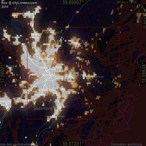
Analysis of Boo night lights 2016
Square area 10x10 km:
100  8.23%
8.23%
90-99 9.96%
80-89 4.33%
70-79 7.58%
60-69 7.68%
50-59 9.2%
40-49 7.25%
30-39 5.63%
20-29 11.26%
10-19 28.57%
0-9 0.32%
8.23%90-99
9.96%80-89
4.33%70-79
7.58%60-69
7.68%50-59
9.2%40-49
7.25%30-39
5.63%20-29
11.26%10-19
28.57%0-9
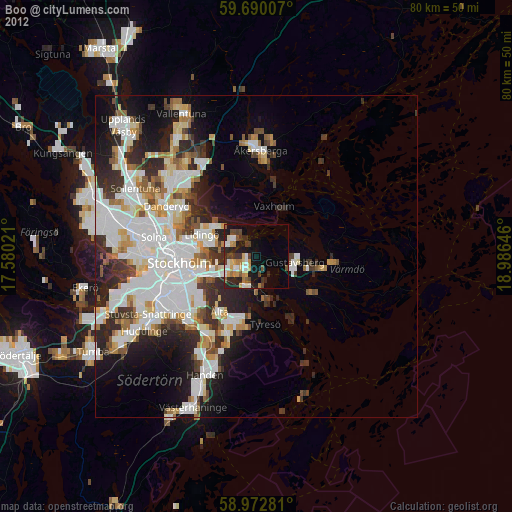
0.32%Square area 50x50 km:
100 10.09%
90-99 8.09%
80-89 2.33%
70-79 3.09%
60-69 2.93%
50-59 2.97%
40-49 4.72%
30-39 3.92%
20-29 5.4%
10-19 10.31%
0-9 46.15%
10.09%90-99
8.09%80-89
2.33%70-79
3.09%60-69
2.93%50-59
2.97%40-49
4.72%30-39
3.92%20-29
5.4%10-19
10.31%0-9
46.15%Clear (daylight) street map image can be seen on geolist.org.
Map coordinates:
59° 41' 24.3" North, 17° 34' 48.8" East
59° 19' 60" North, 18° 16' 60" East
58° 58' 22.1" North, 18° 59' 11.3" East
Some cities around Boo sort by population:
• Lidingö
9.3 km =5.8 mi,  293°
293°
• Östermalm
11.3 km =7 mi,  273°
273°
• Nacka
7.2 km =4.5 mi,  249°
249°
• Gustavsberg
6.1 km =3.8 mi,  96°
96°
• Saltsjöbaden
5.6 km =3.5 mi,  170°
170°
• Älta
9.3 km =5.8 mi,  217°
217°
• Fisksätra
4.9 km =3 mi,  199°
199°
• Brevik
5.1 km =3.2 mi, 291°
2721259 (p: 24,052)
Sources (retrieved 2019-11-25):
» Earth at Night: Flat Maps 2012, 2016