Vyritsa night lights from space
Night Light of Vyritsa (Leningradskaya Oblast') from space (Russia) Src. Average luminocity for 10x10km area is 7.2933% and for 50x50km: 3.7937%.
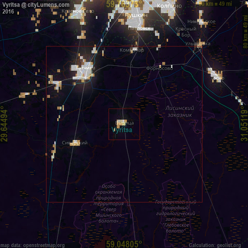
Analysis of Vyritsa night lights 2016
Square area 10x10 km:
 0%
0%90-99
1.41%80-89
1.95%70-79
2.81%60-69
0.76%50-59
0%40-49
0%30-39
0%20-29
0%10-19
0%0-9
93.07%Square area 50x50 km:
0.69%90-99
0.81%80-89
0.55%70-79
0.48%60-69
0.35%50-59
0.12%40-49
0.05%30-39
0.17%20-29
0.93%10-19
2.57%0-9
93.28%Clear (daylight) street map image can be seen on geolist.org.
Map coordinates:
59° 45' 49.4" North, 29° 38' 41.8" East
59° 24' 28" North, 30° 20' 53" East
59° 2' 53" North, 31° 3' 4.3" East
Some cities around Vyritsa sort by population:
• Pushkin
34.2 km =21.3 mi,  4°
4°
• Gatchina
22.5 km =14 mi,  326°
326°
• Tosno
33.3 km =20.7 mi,  63°
63°
• Kommunar
23.8 km =14.8 mi,  5°
5°
• Pavlovsk
31 km =19.3 mi, 9°
• Siverskiy
16.4 km =10.2 mi,  248°
248°
• Ul’yanovka
34.9 km =21.7 mi,  42°
42°
• Mariyenburg
24.2 km =15 mi,  318°
318°
470368 (p: 11,107)
Sources (retrieved 2019-11-25):
» Earth at Night: Flat Maps 2012, 2016