Anapskaya night lights from space
Night Light of Anapskaya (Krasnodarskiy) from space (Russia) Src. Average luminocity for 10x10km area is 43.0619% and for 50x50km: 8.6361%.
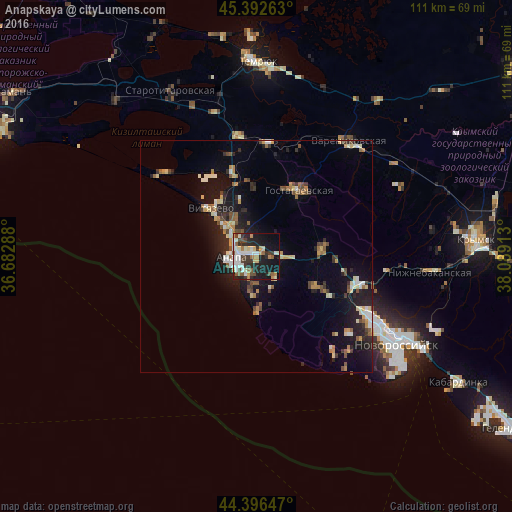
Analysis of Anapskaya night lights 2016
Square area 10x10 km:
 6.67%
6.67%90-99
12.38%80-89
3.97%70-79
3.97%60-69
3.33%50-59
5.71%40-49
6.03%30-39
7.94%20-29
13.97%10-19
25.24%0-9
10.79%Square area 50x50 km:
0.77%90-99
1.48%80-89
0.97%70-79
0.89%60-69
1.04%50-59
1.13%40-49
1.3%30-39
1.04%20-29
2.6%10-19
7.38%0-9
81.39%Clear (daylight) street map image can be seen on geolist.org.
Map coordinates:
45° 23' 33.5" North, 36° 40' 58.4" East
44° 53' 48.2" North, 37° 23' 9.6" East
44° 23' 47.3" North, 38° 5' 20.9" East
Some cities around Anapskaya sort by population:
• Anapa
5.5 km =3.4 mi,  267°
267°
• Varenikovskaya
32 km =19.9 mi,  38°
38°
• Gostagayevskaya
16.9 km =10.5 mi,  33°
33°
• Rayevskaya
15 km =9.3 mi,  116°
116°
• Gayduk
27.7 km =17.2 mi, 116°
• Verkhnebakanskiy
22 km =13.7 mi,  103°
103°
• Vityazevo
14.2 km =8.8 mi,  324°
324°
• Strelka
35.3 km =21.9 mi,  347°
347°
582181 (p: 13,965)
Sources (retrieved 2019-11-25):
» Earth at Night: Flat Maps 2012, 2016