Udomlya night lights from space
Night Light of Udomlya (Tver’ Oblast) from space (Russia) Src. Average luminocity for 10x10km area is 6.7881% and for 50x50km: 0.3022%.
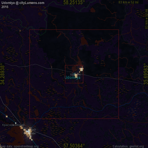

Analysis of Udomlya night lights 2016
Square area 10x10 km:
 0.48%
0.48%90-99
0.83%80-89
0.83%70-79
2.02%60-69
0.12%50-59
1.9%40-49
0.6%30-39
1.79%20-29
0.6%10-19
0.83%0-9
90%Square area 50x50 km:
0.02%90-99
0.03%80-89
0.05%70-79
0.08%60-69
0%50-59
0.07%40-49
0.02%30-39
0.07%20-29
0.02%10-19
0.07%0-9
99.56%Clear (daylight) street map image can be seen on geolist.org.
Map coordinates:
58° 15' 4.9" North, 34° 17' 21.8" East
57° 52' 46" North, 34° 59' 33" East
57° 30' 13.1" North, 35° 41' 44.3" East
Some cities around Udomlya sort by population:
• Borovichi
84.8 km =52.7 mi,  311°
311°
• Vyshniy Volochëk
40.9 km =25.4 mi,  218°
218°
• Bologoye
55.8 km =34.7 mi,  270°
270°
• Bologoye-4
79.4 km =49.3 mi, 271°
• Maksatikha
53.5 km =33.2 mi,  99°
99°
• Spirovo
51.2 km =31.8 mi,  181°
181°
• Krasnomayskiy
45.1 km =28 mi,  230°
230°
• Kalashnikovo
67.8 km =42.1 mi,  168°
168°
452949 (p: 32,373)
Sources (retrieved 2019-11-25):
» Earth at Night: Flat Maps 2012, 2016