Tetyushi night lights from space
Night Light of Tetyushi (Tatarstan Republic) from space (Russia) Src. Average luminocity for 10x10km area is 1.9821% and for 50x50km: 0.1777%.
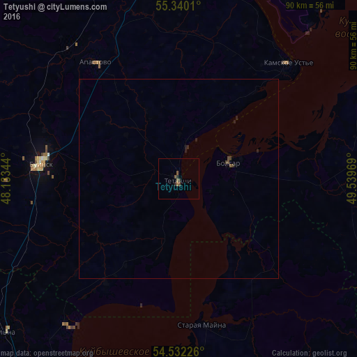
Analysis of Tetyushi night lights 2016
Square area 10x10 km:
 0%
0%90-99
0%80-89
0%70-79
0%60-69
0.96%50-59
0.96%40-49
0.72%30-39
0.24%20-29
0.96%10-19
0%0-9
96.17%Square area 50x50 km:
0%90-99
0%80-89
0%70-79
0%60-69
0.04%50-59
0.06%40-49
0.09%30-39
0.04%20-29
0.14%10-19
0.07%0-9
99.55%Clear (daylight) street map image can be seen on geolist.org.
Map coordinates:
55° 20' 24.4" North, 48° 8' 0.4" East
54° 56' 17.6" North, 48° 50' 11.6" East
54° 31' 56.1" North, 49° 32' 22.9" East
Some cities around Tetyushi sort by population:
• Ulyanovsk
73.7 km =45.8 mi,  203°
203°
• Buinsk
35 km =21.7 mi,  276°
276°
• Cherdakly
64.4 km =40 mi,  179°
179°
• Isheyevka
67.5 km =41.9 mi,  212°
212°
• Bolgar
14.8 km =9.2 mi,  84°
84°
• Laishevo
68.9 km =42.8 mi,  41°
41°
• Staraya Mayna
37.6 km =23.4 mi,  170°
170°
• Bazarnyye Mataki
70.4 km =43.7 mi,  94°
94°
483150 (p: 11,826)
Sources (retrieved 2019-11-25):
» Earth at Night: Flat Maps 2012, 2016