Syas’stroy night lights from space
Night Light of Syas’stroy (Leningradskaya Oblast') from space (Russia) Src. Average luminocity for 10x10km area is 27.3316% and for 50x50km: 3.1449%.
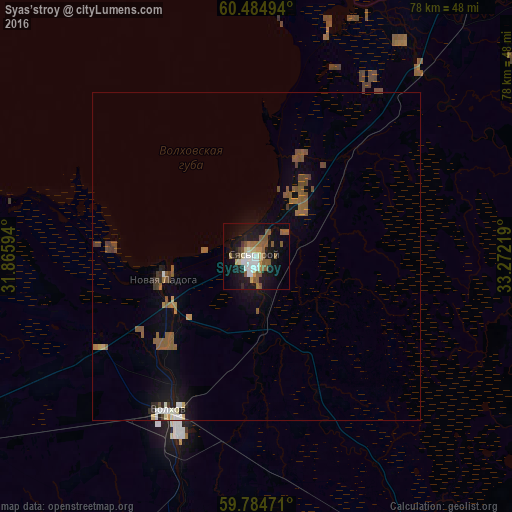
Analysis of Syas’stroy night lights 2016
Square area 10x10 km:
 4.24%
4.24%90-99
3.72%80-89
3.2%70-79
2.07%60-69
4.03%50-59
10.12%40-49
0.93%30-39
0.72%20-29
4.24%10-19
27.27%0-9
39.46%Square area 50x50 km:
0.28%90-99
0.33%80-89
0.25%70-79
0.19%60-69
0.45%50-59
1.29%40-49
0.5%30-39
0.23%20-29
0.35%10-19
2.16%0-9
93.99%Clear (daylight) street map image can be seen on geolist.org.
Map coordinates:
60° 29' 5.8" North, 31° 51' 57.4" East
60° 8' 12.1" North, 32° 34' 8.6" East
59° 47' 5" North, 33° 16' 19.9" East
Some cities around Syas’stroy sort by population:
• Tikhvin
76.5 km =47.5 mi,  135°
135°
• Kirishi
82.6 km =51.3 mi,  201°
201°
• Volkhov
26.7 km =16.6 mi,  208°
208°
• Lodeynoye Pole
84.9 km =52.8 mi,  39°
39°
• Shlissel’burg
87.6 km =54.4 mi,  256°
256°
• Imeni Morozova
86.9 km =54 mi, 258°
• Novaya Ladoga
15.3 km =9.5 mi, 255°
• Priladozhskiy
75.5 km =46.9 mi,  247°
247°
485313 (p: 13,300)
Sources (retrieved 2019-11-25):
» Earth at Night: Flat Maps 2012, 2016