Svetlyy Yar night lights from space
Night Light of Svetlyy Yar (Volgograd Oblast) from space (Russia) Src. Average luminocity for 10x10km area is 2.7159% and for 50x50km: 5.8634%.
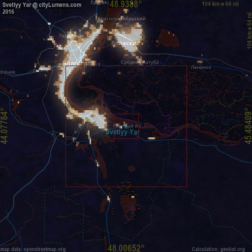
Analysis of Svetlyy Yar night lights 2016
Square area 10x10 km:
 0.57%
0.57%90-99
0%80-89
0%70-79
0%60-69
0%50-59
0.57%40-49
1.42%30-39
0.85%20-29
1.7%10-19
0%0-9
94.89%Square area 50x50 km:
1.07%90-99
1.21%80-89
0.43%70-79
0.5%60-69
0.42%50-59
0.55%40-49
0.56%30-39
0.95%20-29
2.78%10-19
4.74%0-9
86.78%Clear (daylight) street map image can be seen on geolist.org.
Map coordinates:
48° 56' 19.7" North, 44° 4' 40.2" East
48° 28' 29.3" North, 44° 46' 51.5" East
48° 0' 23.5" North, 45° 29' 2.7" East
Some cities around Svetlyy Yar sort by population:
• Volgograd
34.1 km =21.2 mi,  322°
322°
• Volzhskiy
34.6 km =21.5 mi,  359°
359°
• Gorodishche
43 km =26.7 mi,  328°
328°
• Leninsk
39.8 km =24.7 mi,  50°
50°
• Krasnoslobodsk
29.9 km =18.6 mi, 329°
• Srednyaya Akhtuba
26.9 km =16.7 mi,  13°
13°
• Novyy Rogachik
57.5 km =35.7 mi,  292°
292°
• Gumrak
45 km =28 mi, 319°
485643 (p: 13,131)
Sources (retrieved 2019-11-25):
» Earth at Night: Flat Maps 2012, 2016