Stavrovo night lights from space
Night Light of Stavrovo (Vladimir) from space (Russia) Src. Average luminocity for 10x10km area is 1.4438% and for 50x50km: 2.8449%.
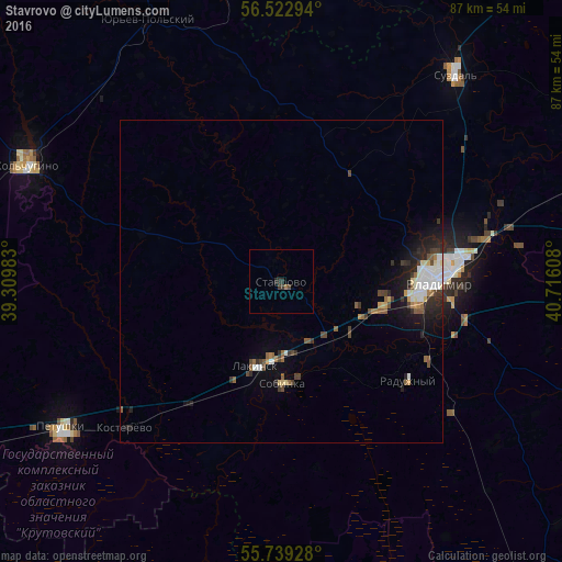
Analysis of Stavrovo night lights 2016
Square area 10x10 km:
 0%
0%90-99
0%80-89
0%70-79
0%60-69
0.48%50-59
0%40-49
0.48%30-39
1.2%20-29
1.2%10-19
0%0-9
96.65%Square area 50x50 km:
0.41%90-99
0.53%80-89
0.23%70-79
0.16%60-69
0.33%50-59
0.42%40-49
0.44%30-39
0.48%20-29
0.91%10-19
1.65%0-9
94.44%Clear (daylight) street map image can be seen on geolist.org.
Map coordinates:
56° 31' 22.6" North, 39° 18' 35.4" East
56° 7' 59.2" North, 40° 0' 46.6" East
55° 44' 21.4" North, 40° 42' 57.9" East
Some cities around Stavrovo sort by population:
• Vladimir
23.8 km =14.8 mi,  89°
89°
• Kol’chugino
43.1 km =26.8 mi,  295°
295°
• Sobinka
16.4 km =10.2 mi,  180°
180°
• Raduzhnyy
24.8 km =15.4 mi,  125°
125°
• Lakinsk
13.3 km =8.3 mi,  197°
197°
• Petushki
41.3 km =25.7 mi,  236°
236°
• Suzdal’
41.9 km =26 mi,  39°
39°
• Kosterevo
33.5 km =20.8 mi,  227°
227°
487837 (p: 7,822)
Sources (retrieved 2019-11-25):
» Earth at Night: Flat Maps 2012, 2016