Persianovka night lights from space
Night Light of Persianovka (Rostov) from space (Russia) Src. Average luminocity for 10x10km area is 0.0043% and for 50x50km: 1.2653%.
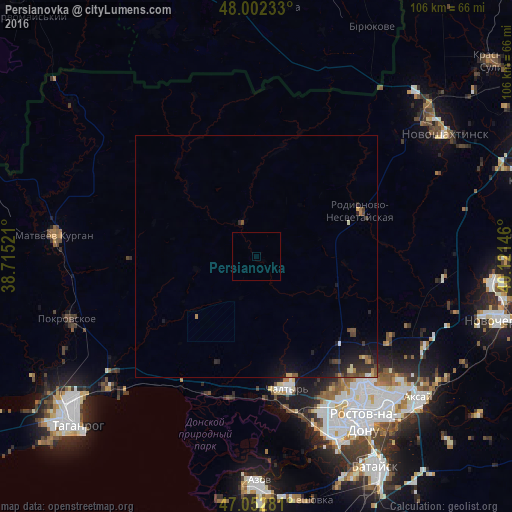
Analysis of Persianovka night lights 2016
Square area 10x10 km:
 0%
0%90-99
0%80-89
0%70-79
0%60-69
0%50-59
0%40-49
0%30-39
0%20-29
0%10-19
0%0-9
100%Square area 50x50 km:
0.02%90-99
0.09%80-89
0.09%70-79
0.14%60-69
0.17%50-59
0.18%40-49
0.31%30-39
0.32%20-29
0.63%10-19
1.38%0-9
96.68%Clear (daylight) street map image can be seen on geolist.org.
Map coordinates:
48° 0' 8.4" North, 38° 42' 54.8" East
47° 31' 47" North, 39° 25' 6" East
47° 3' 10.1" North, 40° 7' 17.3" East
Some cities around Persianovka sort by population:
• Rostov-na-Donu
40.3 km =25 mi,  145°
145°
• Aksay
45.3 km =28.1 mi,  131°
131°
• Chaltyr
27.7 km =17.2 mi,  169°
169°
• Matveyev Kurgan
41.4 km =25.7 mi,  275°
275°
• Pokrovskoye
41.2 km =25.6 mi,  252°
252°
• Rodionovo-Nesvetaiskoye
22.5 km =14 mi,  69°
69°
• Rodionovo-Nesvetayskaya
23.8 km =14.8 mi, 67°
• Sambek
39 km =24.2 mi,  52°
52°
802714 (p: 15,730)
Sources (retrieved 2019-11-25):
» Earth at Night: Flat Maps 2012, 2016