Chaltyr night lights from space
Night Light of Chaltyr (Rostov) from space (Russia) Src. Average luminocity for 10x10km area is 25.619% and for 50x50km: 16.1254%.
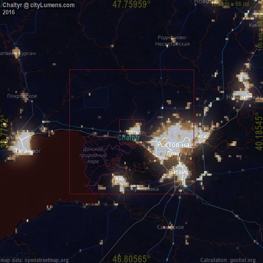
Analysis of Chaltyr night lights 2016
Square area 10x10 km:
 4.32%
4.32%90-99
3.42%80-89
4.17%70-79
3.57%60-69
1.49%50-59
3.42%40-49
4.17%30-39
0.74%20-29
3.27%10-19
33.48%0-9
37.95%Square area 50x50 km:
4.49%90-99
3.85%80-89
1.13%70-79
1.27%60-69
1.26%50-59
1.79%40-49
1.69%30-39
2.36%20-29
3.79%10-19
7.96%0-9
70.41%Clear (daylight) street map image can be seen on geolist.org.
Map coordinates:
47° 45' 34.5" North, 38° 46' 45.1" East
47° 17' 5.2" North, 39° 28' 56.4" East
46° 48' 20.3" North, 40° 11' 7.6" East
Some cities around Chaltyr sort by population:
• Rostov-na-Donu
19.1 km =11.9 mi,  108°
108°
• Bataysk
26 km =16.2 mi,  128°
128°
• Azov
20.3 km =12.6 mi,  194°
194°
• Aksay
29.2 km =18.1 mi,  95°
95°
• Persianovka
27.7 km =17.2 mi,  349°
349°
• Kuleshovka
23.7 km =14.7 mi,  166°
166°
• Rodionovo-Nesvetaiskoye
38.7 km =24 mi,  25°
25°
• Ol’ginskaya
36.9 km =22.9 mi, 106°
570021 (p: 14,689)
Sources (retrieved 2019-11-25):
» Earth at Night: Flat Maps 2012, 2016