Nyrob night lights from space
Night Light of Nyrob (Perm) from space (Russia) Src. Average luminocity for 10x10km area is 2.4361% and for 50x50km: 0.0985%.
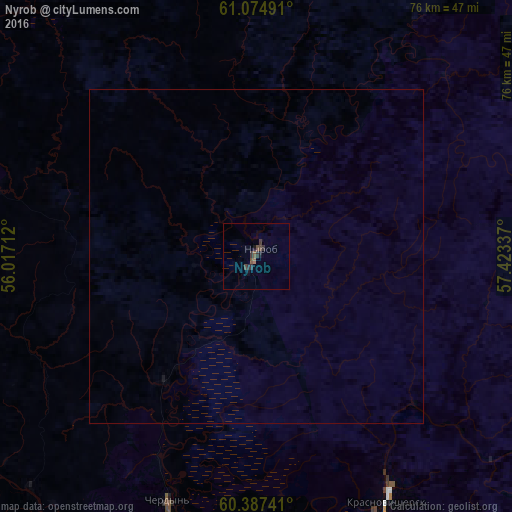
Analysis of Nyrob night lights 2016
Square area 10x10 km:
 0%
0%90-99
0%80-89
0%70-79
0%60-69
0.43%50-59
1.08%40-49
0.97%30-39
1.19%20-29
1.52%10-19
1.3%0-9
93.51%Square area 50x50 km:
0%90-99
0%80-89
0%70-79
0%60-69
0.02%50-59
0.04%40-49
0.04%30-39
0.05%20-29
0.06%10-19
0.07%0-9
99.73%Clear (daylight) street map image can be seen on geolist.org.
Map coordinates:
61° 4' 29.7" North, 56° 1' 1.6" East
60° 43' 58.8" North, 56° 43' 12.9" East
60° 23' 14.7" North, 57° 25' 24.1" East
Some cities around Nyrob sort by population:
• Berezniki
147.3 km =91.5 mi,  177°
177°
• Solikamsk
122.5 km =76.1 mi, 178°
• Krasnovishersk
41.2 km =25.6 mi,  151°
151°
• Aleksandrovsk
181.4 km =112.7 mi,  164°
164°
• Yayva
158.3 km =98.4 mi,  169°
169°
• Cherëmukhovo
183.6 km =114.1 mi,  103°
103°
• Cherdyn’
39 km =24.2 mi,  199°
199°
• Usol’ye
145.8 km =90.6 mi, 180°
516588 (p: 7,314)
Sources (retrieved 2019-11-25):
» Earth at Night: Flat Maps 2012, 2016