Lakhtinskiy night lights from space
Night Light of Lakhtinskiy (St.-Petersburg) from space (Russia) Src. Average luminocity for 10x10km area is 57.013% and for 50x50km: 53.2945%.
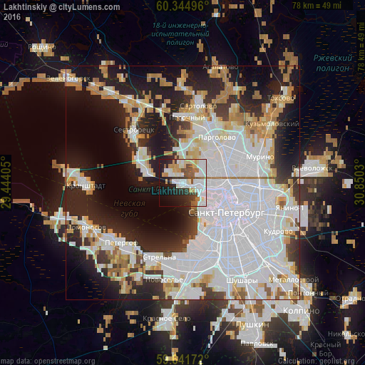
Analysis of Lakhtinskiy night lights 2016
Square area 10x10 km:
 17.1%
17.1%90-99
16.99%80-89
4.65%70-79
6.39%60-69
3.35%50-59
6.49%40-49
4.33%30-39
4.65%20-29
11.58%10-19
16.67%0-9
7.79%Square area 50x50 km:
23.1%90-99
10.75%80-89
4.47%70-79
5.64%60-69
4.77%50-59
2.33%40-49
1.73%30-39
4.06%20-29
10.78%10-19
15.11%0-9
17.25%Clear (daylight) street map image can be seen on geolist.org.
Map coordinates:
60° 20' 41.9" North, 29° 26' 38.6" East
59° 59' 42.8" North, 30° 8' 49.8" East
59° 38' 30.2" North, 30° 51' 1.1" East
Some cities around Lakhtinskiy sort by population:
• Vasyl'evsky Ostrov
8.5 km =5.3 mi,  135°
135°
• Komendantsky aerodrom
7.2 km =4.5 mi,  81°
81°
• Chernaya Rechka
8.7 km =5.4 mi,  96°
96°
• Untolovo
3.9 km =2.4 mi,  61°
61°
• Kolomyagi
8.3 km =5.2 mi,  67°
67°
• Staraya Derevnya
5.4 km =3.4 mi, 98°
• Novaya Derevnya
7.8 km =4.8 mi, 96°
• Krestovskiy ostrov
6.7 km =4.2 mi,  113°
113°
537127 (p: 10,000)
Sources (retrieved 2019-11-25):
» Earth at Night: Flat Maps 2012, 2016