Kenzhe night lights from space
Night Light of Kenzhe (Kabardino-Balkariya Republic) from space (Russia) Src. Average luminocity for 10x10km area is 39.0984% and for 50x50km: 5.6462%.
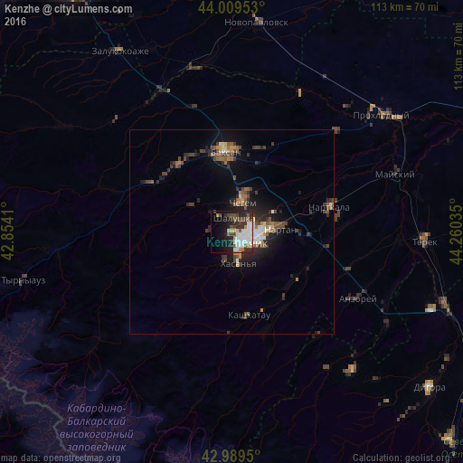
Analysis of Kenzhe night lights 2016
Square area 10x10 km:
 12.06%
90-99
8.25%80-89
3.17%70-79
2.54%60-69
1.43%50-59
4.29%40-49
4.92%30-39
7.78%20-29
12.7%10-19
15.08%0-9
27.78%Square area 50x50 km:
0.78%90-99
0.65%80-89
0.4%70-79
0.39%60-69
0.65%50-59
0.99%40-49
1.34%30-39
1.28%20-29
2.02%10-19
3.83%0-9
87.66%Clear (daylight) street map image can be seen on geolist.org.
Map coordinates:
44° 0' 34.3" North, 42° 51' 14.8" East
43° 30' 6" North, 43° 33' 26" East
42° 59' 22.2" North, 44° 15' 37.3" East
Some cities around Kenzhe sort by population:
• Nal’chik
5 km =3.1 mi,  94°
94°
• Dugulubgey
18 km =11.2 mi,  354°
354°
• Chegem
7 km =4.3 mi,  24°
24°
• Nartan
11.5 km =7.1 mi,  84°
84°
• Shalushka
3.5 km =2.2 mi,  11°
11°
• Chegem Vtoroy
11 km =6.8 mi, 18°
• Urvan’
16.4 km =10.2 mi, 93°
• Kashkhatau
20.8 km =12.9 mi,  168°
168°
551070 (p: 10,636)
Sources (retrieved 2019-11-25):
» Earth at Night: Flat Maps 2012, 2016