Ilanskiy night lights from space
Night Light of Ilanskiy (Krasnoyarskiy) from space (Russia) Src. Average luminocity for 10x10km area is 12.5191% and for 50x50km: 2.8794%.
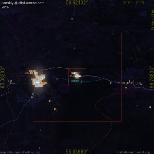
Analysis of Ilanskiy night lights 2016
Square area 10x10 km:
 2.03%
2.03%90-99
3.11%80-89
0.6%70-79
0.48%60-69
1.91%50-59
2.39%40-49
0.96%30-39
0.96%20-29
0.48%10-19
4.67%0-9
82.42%Square area 50x50 km:
0.61%90-99
0.74%80-89
0.23%70-79
0.22%60-69
0.33%50-59
0.24%40-49
0.09%30-39
0.36%20-29
0.72%10-19
1.9%0-9
94.56%Clear (daylight) street map image can be seen on geolist.org.
Map coordinates:
56° 37' 16.8" North, 95° 21' 43.5" East
56° 13' 57" North, 96° 3' 54.7" East
55° 50' 22.9" North, 96° 46' 6" East
Some cities around Ilanskiy sort by population:
• Kansk
21.8 km =13.5 mi,  260°
260°
• Zelenogorsk
91.8 km =57 mi, 261°
• Borodino
80.5 km =50 mi,  243°
243°
• Aban
49.6 km =30.8 mi,  0°
0°
• Nizhnyaya Poyma
71 km =44.1 mi,  96°
96°
• Nizhniy Ingash
29.4 km =18.3 mi, 96°
• Dzerzhinskoye
84.3 km =52.4 mi,  322°
322°
• Yurty
99.3 km =61.7 mi, 101°
1505933 (p: 16,668)
Sources (retrieved 2019-11-25):
» Earth at Night: Flat Maps 2012, 2016