Beregovoy night lights from space
Night Light of Beregovoy (Omsk) from space (Russia) Src. Average luminocity for 10x10km area is 5.2907% and for 50x50km: 11.187%.
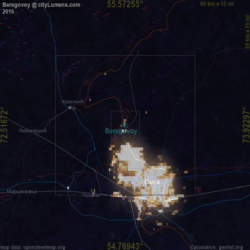
Analysis of Beregovoy night lights 2016
Square area 10x10 km:
 0.25%
0.25%90-99
0.25%80-89
0%70-79
0%60-69
0.13%50-59
1.38%40-49
0.5%30-39
1%20-29
0.75%10-19
13.53%0-9
82.21%Square area 50x50 km:
3.4%90-99
3.13%80-89
0.97%70-79
1.01%60-69
0.98%50-59
0.88%40-49
0.87%30-39
1.13%20-29
2.44%10-19
3.17%0-9
82.02%Clear (daylight) street map image can be seen on geolist.org.
Map coordinates:
55° 34' 21.2" North, 72° 31' 0.2" East
55° 10' 22.8" North, 73° 13' 11.4" East
54° 46' 9.9" North, 73° 55' 22.7" East
Some cities around Beregovoy sort by population:
• Omsk
22.2 km =13.8 mi,  154°
154°
• Lyubinskiy
33.6 km =20.9 mi,  266°
266°
• Luzino
27.6 km =17.1 mi,  205°
205°
• Sargatskoye
51.7 km =32.1 mi,  19°
19°
• Vkhodnoy
24.8 km =15.4 mi,  187°
187°
• Krutaya Gorka
21.3 km =13.2 mi,  0°
0°
• Krasnyy Yar
20.2 km =12.6 mi,  292°
292°
• Azovo
54.1 km =33.6 mi, 193°
1510335 (p: 7,961)
Sources (retrieved 2019-11-25):
» Earth at Night: Flat Maps 2012, 2016