Žabalj night lights from space
Night Light of Žabalj (Vojvodina) from space (Serbia) Src. Average luminocity for 10x10km area is 5.5984% and for 50x50km: 11.3457%.
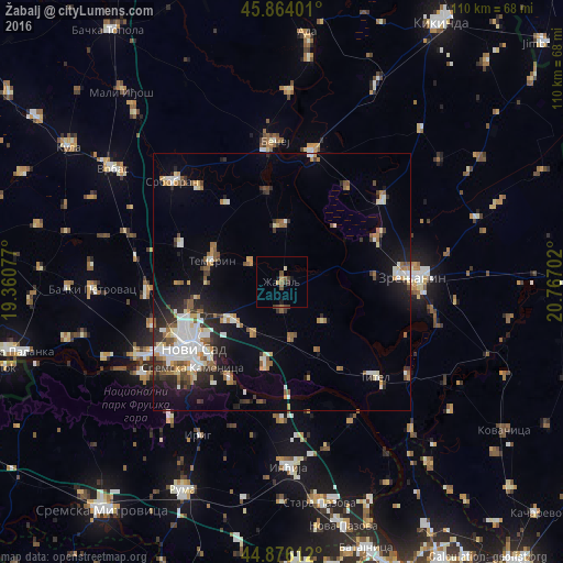
Analysis of Žabalj night lights 2016
Square area 10x10 km:
 0%
0%90-99
0.16%80-89
0.48%70-79
0.32%60-69
1.11%50-59
1.9%40-49
1.59%30-39
2.22%20-29
0.16%10-19
1.9%0-9
90.16%Square area 50x50 km:
1.8%90-99
2.14%80-89
1.07%70-79
1.11%60-69
1.21%50-59
1.64%40-49
1.25%30-39
1.55%20-29
2.55%10-19
5.7%0-9
79.97%Clear (daylight) street map image can be seen on geolist.org.
Map coordinates:
45° 51' 50.4" North, 19° 21' 38.8" East
45° 22' 20" North, 20° 3' 50" East
44° 52' 34" North, 20° 46' 1.3" East
Some cities around Žabalj sort by population:
• Novi Sad
22.2 km =13.8 mi,  232°
232°
• Zrenjanin
24.9 km =15.5 mi,  87°
87°
• Petrovaradin
20.1 km =12.5 mi, 225°
• Čurug
11.1 km =6.9 mi,  1°
1°
• Sremski Karlovci
21.4 km =13.3 mi,  208°
208°
• Melenci
25.6 km =15.9 mi,  51°
51°
• Bačko Gradište
18 km =11.2 mi,  351°
351°
• Kovilj
15.7 km =9.8 mi,  191°
191°
784068 (p: 8,503)
Sources (retrieved 2019-11-25):
» Earth at Night: Flat Maps 2012, 2016