Stara Pazova night lights from space
Night Light of Stara Pazova (Vojvodina) from space (Serbia) Src. Average luminocity for 10x10km area is 31.8794% and for 50x50km: 19.2059%.
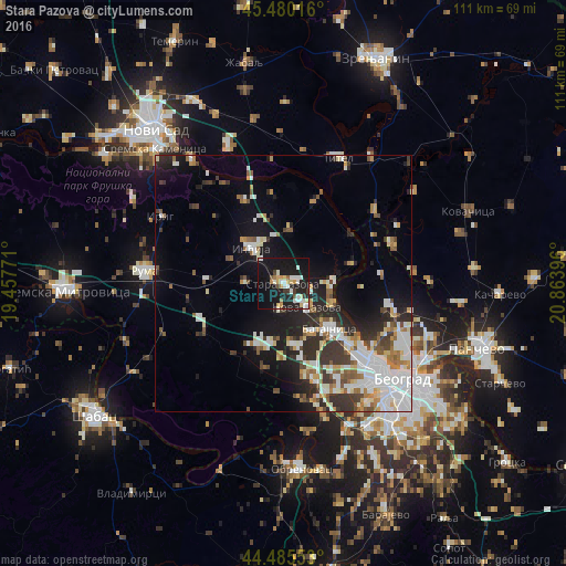
Analysis of Stara Pazova night lights 2016
Square area 10x10 km:
 5.24%
5.24%90-99
7.62%80-89
3.49%70-79
4.13%60-69
2.22%50-59
1.43%40-49
1.27%30-39
3.33%20-29
7.78%10-19
46.83%0-9
16.67%Square area 50x50 km:
3.98%90-99
4.64%80-89
1.55%70-79
1.84%60-69
1.68%50-59
2.15%40-49
1.91%30-39
2.89%20-29
4.6%10-19
10.52%0-9
64.23%Clear (daylight) street map image can be seen on geolist.org.
Map coordinates:
45° 28' 48.6" North, 19° 27' 27.8" East
44° 59' 6" North, 20° 9' 39" East
44° 29' 7.9" North, 20° 51' 50.3" East
Some cities around Stara Pazova sort by population:
• Zemun
24.4 km =15.2 mi,  129°
129°
• Ruma
26.7 km =16.6 mi,  275°
275°
• Inđija
9.4 km =5.8 mi,  318°
318°
• Nova Pazova
6.5 km =4 mi, 134°
• Surčin
23.3 km =14.5 mi,  156°
156°
• Dobanovci
18.4 km =11.4 mi, 164°
• Beška
17.8 km =11.1 mi,  335°
335°
• Titel
26.7 km =16.6 mi,  23°
23°
785559 (p: 16,217)
Sources (retrieved 2019-11-25):
» Earth at Night: Flat Maps 2012, 2016