Badovinci night lights from space
Night Light of Badovinci (Central Serbia) from space (Serbia) Src. Average luminocity for 10x10km area is 7.6955% and for 50x50km: 5.1711%.
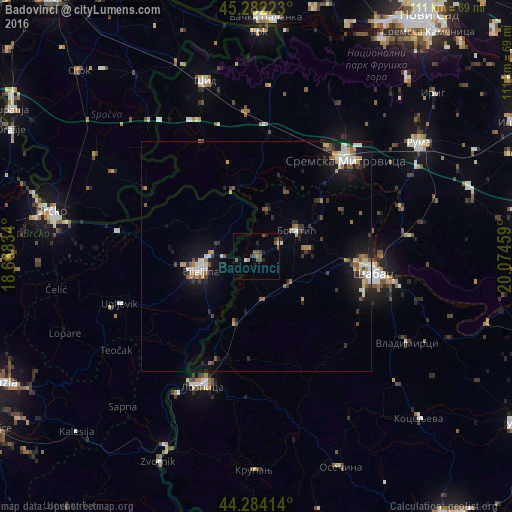
Analysis of Badovinci night lights 2016
Square area 10x10 km:
 0%
0%90-99
0.91%80-89
0%70-79
0.3%60-69
0.76%50-59
5.15%40-49
1.97%30-39
0.91%20-29
2.27%10-19
0.76%0-9
86.97%Square area 50x50 km:
0.55%90-99
0.86%80-89
0.37%70-79
0.64%60-69
0.56%50-59
0.93%40-49
0.6%30-39
0.76%20-29
1.16%10-19
4.13%0-9
89.44%Clear (daylight) street map image can be seen on geolist.org.
Map coordinates:
45° 16' 56" North, 18° 40' 6" East
44° 47' 7.2" North, 19° 22' 17.3" East
44° 17' 2.9" North, 20° 4' 28.5" East
Some cities around Badovinci sort by population:
• Šabac
25.5 km =15.8 mi,  99°
99°
• Sremska Mitrovica
28.5 km =17.7 mi,  41°
41°
• Bijeljina, BA
12.7 km =7.9 mi,  256°
256°
• Ruma
43.3 km =26.9 mi,  55°
55°
• Bogatić
10.4 km =6.5 mi, 56°
• Janja, BA
16.6 km =10.3 mi,  216°
216°
• Velika Obarska, BA
16.7 km =10.4 mi,  277°
277°
• Gunja, HR
42.2 km =26.2 mi, 284°
3204635 (p: 5,879)
Sources (retrieved 2019-11-25):
» Earth at Night: Flat Maps 2012, 2016