Ceptura de Sus night lights from space
Night Light of Ceptura de Sus (Prahova) from space (Romania) Src. Average luminocity for 10x10km area is 0.5254% and for 50x50km: 3.7626%.
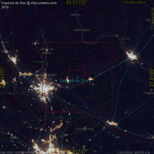
Analysis of Ceptura de Sus night lights 2016
Square area 10x10 km:
 0%
0%90-99
0%80-89
0%70-79
0%60-69
0%50-59
0%40-49
0%30-39
0%20-29
1.27%10-19
0%0-9
98.73%Square area 50x50 km:
0.65%90-99
0.63%80-89
0.2%70-79
0.24%60-69
0.57%50-59
0.57%40-49
0.78%30-39
0.82%20-29
1.28%10-19
1.88%0-9
92.38%Clear (daylight) street map image can be seen on geolist.org.
Map coordinates:
45° 30' 41.6" North, 25° 36' 48.8" East
45° 1' 0" North, 26° 19' 0" East
44° 31' 2.9" North, 27° 1' 11.3" East
Some cities around Ceptura de Sus sort by population:
• Mizil
10.5 km =6.5 mi,  90°
90°
• Urlaţi
7.5 km =4.7 mi,  240°
240°
• Valea Călugărească
14.2 km =8.8 mi,  247°
247°
• Berceni
18.3 km =11.4 mi, 239°
• Albeşti-Paleologu
10.8 km =6.7 mi,  226°
226°
• Colceag
7.9 km =4.9 mi,  160°
160°
• Sângeru
13.2 km =8.2 mi,  11°
11°
• Moceşti
6.4 km =4 mi,  305°
305°
682403 (p: 5,204)
Sources (retrieved 2019-11-25):
» Earth at Night: Flat Maps 2012, 2016