Teiuş night lights from space
Night Light of Teiuş (Alba) from space (Romania) Src. Average luminocity for 10x10km area is 2.0767% and for 50x50km: 2.1418%.
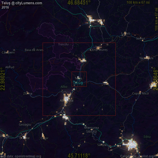
Analysis of Teiuş night lights 2016
Square area 10x10 km:
100  0.28%
0.28%
90-99 0.28%
80-89 0%
70-79 0%
60-69 0.14%
50-59 0.43%
40-49 0.85%
30-39 0.85%
20-29 0.43%
10-19 0.71%
0-9 96.02%
0.28%90-99
0.28%80-89
0%70-79
0%60-69
0.14%50-59
0.43%40-49
0.85%30-39
0.85%20-29
0.43%10-19
0.71%0-9
96.02%Square area 50x50 km:
100 0.23%
90-99 0.31%
80-89 0.21%
70-79 0.27%
60-69 0.25%
50-59 0.21%
40-49 0.32%
30-39 0.31%
20-29 0.32%
10-19 1.91%
0-9 95.66%
0.23%90-99
0.31%80-89
0.21%70-79
0.27%60-69
0.25%50-59
0.21%40-49
0.32%30-39
0.31%20-29
0.32%10-19
1.91%0-9
95.66%Clear (daylight) street map image can be seen on geolist.org.
Map coordinates:
46° 41' 4.2" North, 22° 58' 48.8" East
46° 12' 0" North, 23° 40' 60" East
45° 42' 40.2" North, 24° 23' 11.3" East
Some cities around Teiuş sort by population:
• Alba Iulia
16.7 km =10.4 mi,  207°
207°
• Aiud
12.6 km =7.8 mi,  13°
13°
• Sebeş
28.4 km =17.6 mi,  197°
197°
• Blaj
18.1 km =11.2 mi,  98°
98°
• Ocna Mureş
24.1 km =15 mi,  32°
32°
• Zlatna
36.3 km =22.6 mi,  253°
253°
• Ighiu
14 km =8.7 mi, 246°
• Vurpăr
27.8 km =17.3 mi,  216°
216°
665318 (p: 7,112)
Sources (retrieved 2019-11-25):
» Earth at Night: Flat Maps 2012, 2016