Ighiu night lights from space
Night Light of Ighiu (Alba) from space (Romania) Src. Average luminocity for 10x10km area is 2.0582% and for 50x50km: 2.3608%.
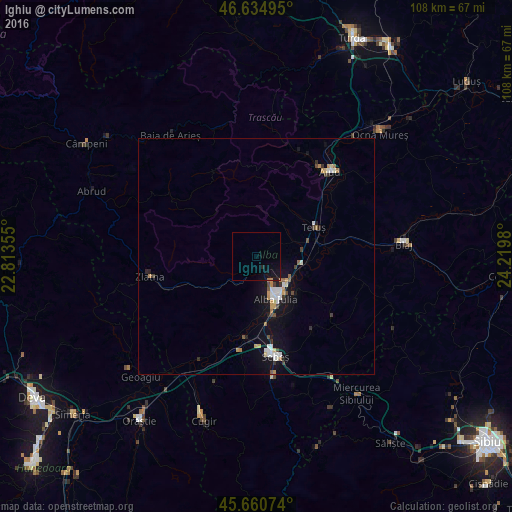
Analysis of Ighiu night lights 2016
Square area 10x10 km:
100  0%
0%
90-99 0%
80-89 0%
70-79 0.28%
60-69 0.43%
50-59 0%
40-49 0%
30-39 0%
20-29 0.57%
10-19 4.69%
0-9 94.03%
0%90-99
0%80-89
0%70-79
0.28%60-69
0.43%50-59
0%40-49
0%30-39
0%20-29
0.57%10-19
4.69%0-9
94.03%Square area 50x50 km:
100 0.31%
90-99 0.43%
80-89 0.21%
70-79 0.3%
60-69 0.24%
50-59 0.2%
40-49 0.28%
30-39 0.25%
20-29 0.27%
10-19 2.14%
0-9 95.38%
0.31%90-99
0.43%80-89
0.21%70-79
0.3%60-69
0.24%50-59
0.2%40-49
0.28%30-39
0.25%20-29
0.27%10-19
2.14%0-9
95.38%Clear (daylight) street map image can be seen on geolist.org.
Map coordinates:
46° 38' 5.8" North, 22° 48' 48.8" East
46° 9' 0" North, 23° 31' 0" East
45° 39' 38.7" North, 24° 13' 11.3" East
Some cities around Ighiu sort by population:
• Alba Iulia
10.6 km =6.6 mi,  150°
150°
• Aiud
23.8 km =14.8 mi,  41°
41°
• Sebeş
21.9 km =13.6 mi,  168°
168°
• Blaj
30.9 km =19.2 mi,  84°
84°
• Zlatna
22.5 km =14 mi,  257°
257°
• Teiuş
14 km =8.7 mi,  66°
66°
• Săsciori
31.9 km =19.8 mi, 170°
• Vurpăr
17.1 km =10.6 mi,  193°
193°
675703 (p: 6,294)
Sources (retrieved 2019-11-25):
» Earth at Night: Flat Maps 2012, 2016