Strehaia night lights from space
Night Light of Strehaia (Mehedinţi) from space (Romania) Src. Average luminocity for 10x10km area is 2.0424% and for 50x50km: 0.511%.
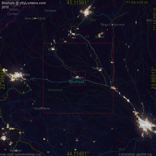
Analysis of Strehaia night lights 2016
Square area 10x10 km:
 0%
0%90-99
0%80-89
0.61%70-79
0%60-69
0.61%50-59
0%40-49
0.61%30-39
0.61%20-29
1.06%10-19
1.82%0-9
94.7%Square area 50x50 km:
0.04%90-99
0.01%80-89
0.12%70-79
0.08%60-69
0.09%50-59
0.04%40-49
0.09%30-39
0.13%20-29
0.19%10-19
0.24%0-9
98.98%Clear (daylight) street map image can be seen on geolist.org.
Map coordinates:
45° 6' 54" North, 22° 29' 48.8" East
44° 37' 0" North, 23° 12' 0" East
44° 6' 50.4" North, 23° 54' 11.3" East
Some cities around Strehaia sort by population:
• Motru
27.5 km =17.1 mi,  319°
319°
• Filiaşi
26.2 km =16.3 mi,  106°
106°
• Rovinari
33.4 km =20.8 mi,  357°
357°
• Turceni
15.1 km =9.4 mi,  60°
60°
• Plopşoru
22 km =13.7 mi,  32°
32°
• Corcova
15.1 km =9.4 mi,  307°
307°
• Mătăsari
27.5 km =17.1 mi,  340°
340°
• Ţicleni
33.6 km =20.9 mi, 28°
665997 (p: 11,607)
Sources (retrieved 2019-11-25):
» Earth at Night: Flat Maps 2012, 2016