Şirna night lights from space
Night Light of Şirna (Prahova) from space (Romania) Src. Average luminocity for 10x10km area is 0.9698% and for 50x50km: 9.1061%.
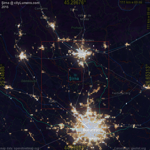
Analysis of Şirna night lights 2016
Square area 10x10 km:
 0%
0%90-99
0%80-89
0%70-79
0%60-69
0%50-59
0.63%40-49
0%30-39
0%20-29
0%10-19
0.16%0-9
99.21%Square area 50x50 km:
1.16%90-99
1.36%80-89
0.44%70-79
0.48%60-69
1.35%50-59
1.25%40-49
2.19%30-39
2.24%20-29
3.33%10-19
6.39%0-9
79.81%Clear (daylight) street map image can be seen on geolist.org.
Map coordinates:
45° 17' 48.3" North, 25° 14' 48.8" East
44° 48' 0" North, 25° 57' 0" East
44° 17' 56.1" North, 26° 39' 11.3" East
Some cities around Şirna sort by population:
• Bărcăneşti
12.2 km =7.6 mi,  40°
40°
• Puchenii Mari
10.7 km =6.6 mi,  80°
80°
• Târgşoru Vechi
7.9 km =4.9 mi,  340°
340°
• Brazii de Sus
9.1 km =5.7 mi, 35°
• Corneşti
6.8 km =4.2 mi,  254°
254°
• Cojasca
12.2 km =7.6 mi,  220°
220°
• Măneşti
10.8 km =6.7 mi,  313°
313°
• Gorgota
10.7 km =6.6 mi,  99°
99°
666809 (p: 5,331)
Sources (retrieved 2019-11-25):
» Earth at Night: Flat Maps 2012, 2016