Cojasca night lights from space
Night Light of Cojasca (Dâmboviţa) from space (Romania) Src. Average luminocity for 10x10km area is 1.7515% and for 50x50km: 11.2151%.
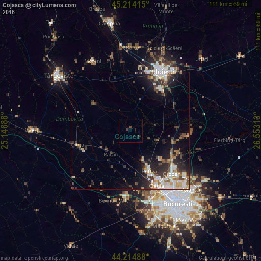
Analysis of Cojasca night lights 2016
Square area 10x10 km:
 0%
0%90-99
0%80-89
0%70-79
0%60-69
0%50-59
0%40-49
1.82%30-39
0.61%20-29
1.36%10-19
1.67%0-9
94.55%Square area 50x50 km:
1.61%90-99
2.3%80-89
1.02%70-79
1.1%60-69
1.5%50-59
1.17%40-49
2.02%30-39
2.33%20-29
3.48%10-19
5.82%0-9
77.66%Clear (daylight) street map image can be seen on geolist.org.
Map coordinates:
45° 12' 50.9" North, 25° 8' 48.8" East
44° 43' 0" North, 25° 51' 0" East
44° 12' 53.6" North, 26° 33' 11.3" East
Some cities around Cojasca sort by population:
• Corneşti
7.5 km =4.7 mi,  10°
10°
• Periş
13.4 km =8.3 mi,  105°
105°
• Măneşti
16.7 km =10.4 mi,  0°
0°
• Răcari
13.1 km =8.1 mi,  224°
224°
• Crevedia
14.6 km =9.1 mi,  153°
153°
• Ciocăneşti
13 km =8.1 mi,  180°
180°
• Şirna
12.2 km =7.6 mi,  40°
40°
• Tărtăşeşti
15.8 km =9.8 mi,  190°
190°
681151 (p: 7,205)
Sources (retrieved 2019-11-25):
» Earth at Night: Flat Maps 2012, 2016