Bărcăneşti night lights from space
Night Light of Bărcăneşti (Prahova) from space (Romania) Src. Average luminocity for 10x10km area is 33.1429% and for 50x50km: 7.6096%.
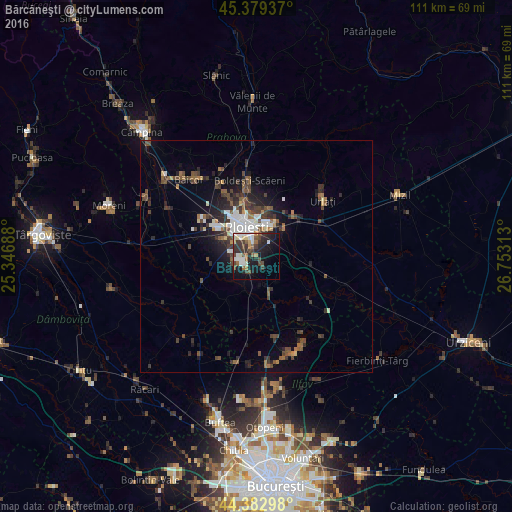
Analysis of Bărcăneşti night lights 2016
Square area 10x10 km:
 4.92%
4.92%90-99
6.67%80-89
2.22%70-79
2.7%60-69
4.13%50-59
3.65%40-49
6.83%30-39
9.52%20-29
10.79%10-19
22.7%0-9
25.87%Square area 50x50 km:
1.06%90-99
1.17%80-89
0.39%70-79
0.36%60-69
0.94%50-59
1.2%40-49
1.99%30-39
1.87%20-29
2.51%10-19
4.29%0-9
84.24%Clear (daylight) street map image can be seen on geolist.org.
Map coordinates:
45° 22' 45.7" North, 25° 20' 48.8" East
44° 52' 60" North, 26° 3' 0" East
44° 22' 58.7" North, 26° 45' 11.3" East
Some cities around Bărcăneşti sort by population:
• Ploieşti
7.9 km =4.9 mi,  340°
340°
• Bucov
9.6 km =6 mi,  15°
15°
• Puchenii Mari
7.9 km =4.9 mi,  160°
160°
• Târgşoru Vechi
10.7 km =6.6 mi,  260°
260°
• Brazii de Sus
3.2 km =2 mi,  234°
234°
• Berceni
7.6 km =4.7 mi,  43°
43°
• Râfov
6.8 km =4.2 mi,  105°
105°
• Gorgota
11.4 km =7.1 mi,  166°
166°
685354 (p: 9,225)
Sources (retrieved 2019-11-25):
» Earth at Night: Flat Maps 2012, 2016