Puchenii Mari night lights from space
Night Light of Puchenii Mari (Prahova) from space (Romania) Src. Average luminocity for 10x10km area is 3.7794% and for 50x50km: 8.4479%.
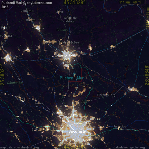
Analysis of Puchenii Mari night lights 2016
Square area 10x10 km:
 0%
0%90-99
0%80-89
0%70-79
0%60-69
0.32%50-59
0.63%40-49
2.06%30-39
1.27%20-29
0.79%10-19
4.29%0-9
90.63%Square area 50x50 km:
1.08%90-99
1.25%80-89
0.42%70-79
0.5%60-69
1.27%50-59
1.32%40-49
1.94%30-39
2.1%20-29
2.75%10-19
5.82%0-9
81.54%Clear (daylight) street map image can be seen on geolist.org.
Map coordinates:
45° 18' 47.8" North, 25° 22' 48.8" East
44° 49' 0" North, 26° 4' 60" East
44° 18' 56.7" North, 26° 47' 11.3" East
Some cities around Puchenii Mari sort by population:
• Bărcăneşti
7.9 km =4.9 mi,  340°
340°
• Târgşoru Vechi
14.3 km =8.9 mi,  292°
292°
• Brazii de Sus
7.7 km =4.8 mi,  316°
316°
• Gruiu
15 km =9.3 mi,  128°
128°
• Berceni
13.2 km =8.2 mi,  11°
11°
• Râfov
6.8 km =4.2 mi,  35°
35°
• Gorgota
3.7 km =2.3 mi,  180°
180°
• Şirna
10.7 km =6.6 mi,  260°
260°
669522 (p: 8,869)
Sources (retrieved 2019-11-25):
» Earth at Night: Flat Maps 2012, 2016