Săvineşti night lights from space
Night Light of Săvineşti (Neamţ) from space (Romania) Src. Average luminocity for 10x10km area is 2.8914% and for 50x50km: 1.2243%.
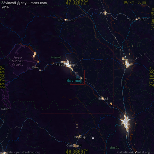
Analysis of Săvineşti night lights 2016
Square area 10x10 km:
 0%
0%90-99
0%80-89
0%70-79
0.3%60-69
0%50-59
0.6%40-49
0.6%30-39
1.64%20-29
2.23%10-19
1.64%0-9
93.01%Square area 50x50 km:
0.16%90-99
0.21%80-89
0.12%70-79
0.16%60-69
0.05%50-59
0.11%40-49
0.19%30-39
0.23%20-29
0.2%10-19
1.06%0-9
97.53%Clear (daylight) street map image can be seen on geolist.org.
Map coordinates:
47° 19' 43.4" North, 25° 45' 48.8" East
46° 51' 0" North, 26° 28' 0" East
46° 22' 1.1" North, 27° 10' 11.3" East
Some cities around Săvineşti sort by population:
• Piatra Neamţ
12.6 km =7.8 mi,  306°
306°
• Borleşti
9.4 km =5.8 mi,  172°
172°
• Roznov
4.2 km =2.6 mi,  115°
115°
• Piatra Şoimului
3.1 km =1.9 mi,  233°
233°
• Girov
11.7 km =7.3 mi,  18°
18°
• Dumbrava Roşie
4.5 km =2.8 mi,  325°
325°
• Zăneşti
7.3 km =4.5 mi, 120°
• Podoleni
12.7 km =7.9 mi, 115°
667751 (p: 6,012)
Sources (retrieved 2019-11-25):
» Earth at Night: Flat Maps 2012, 2016